IMAGES TAKEN NEAR TO
Greyfriars Drive, PRESTON, PR1 9XJ
Introduction
This page details the photographs taken nearby to Greyfriars Drive, PR1 9XJ by members of the Geograph project.
The Geograph project started in 2005 with the aim of publishing, organising and preserving representative images for every square kilometre of Great Britain, Ireland and the Isle of Man.

There are currently over 7.5m images from over14,400 individuals and you can help contribute to the project by visiting https://www.geograph.org.uk
Image Map
Images are licensed for reuse under creativecommons.org/licenses/by-sa/2.0
Notes
- Clicking on the map will re-center to the selected point.
- The higher the marker number, the further away the image location is from the centre of the postcode.
Image Listing (29 Images Found)
Images are licensed for reuse under creativecommons.org/licenses/by-sa/2.0
Image
Details
Distance
1
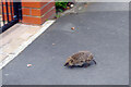
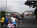
Hedgehog at Penwortham
What exactly this little fellow was doing running around on Hill Road in the middle of the day is hard to say. It certainly wasn't a safe place for it. It is to be hoped that it found a safe burrow before it came to any harm.
Image: © Stephen McKay
Taken: 19 Apr 2023
0.04 miles
2
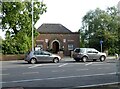
Penwortham Arts Centre
Formerly the library.
Image: © Gerald England
Taken: 13 May 2022
0.05 miles
4
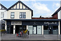
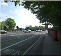
Penwortham micropubs
1260 Craft & Crust and GINjarALE are almost, but not quite, next door to each other. There are two other micropubs very close. 1260 was the year of the first known reference to the Penwortham name.
Image: © Stephen McKay
Taken: 19 Apr 2023
0.11 miles
5
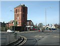
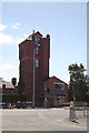
Penwortham water tower
Penwortham water tower is a local landmark dating from Victorian days.
Image: © Galatas
Taken: 2 Mar 2008
0.11 miles
6
Penwortham Water Tower
The brick tower was completed in 1890 by Lawrence Rawstorne, to provide the town with a water supply. It continued in this capacity until 1895 when new water pipes and a mains system were installed in what was then a village. It has since been converted into private residential apartments. A ground floor unit had been occupied by estate agents Reeds Rains. When they moved out a pizza chain applied to move in but they were rejected. The space is now occupied Inkarma a private tattoo studio.
Image: © Gerald England
Taken: 13 May 2022
0.12 miles
7
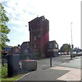
Reed Rains Estate Agent, Penwortham
Occupying a former water tower.
Image: © Mike Pennington
Taken: 8 Aug 2016
0.12 miles
9
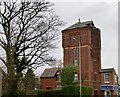
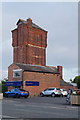
The Water Tower, Penwortham
This water tower was erected in 1880, to upgrade Penwortham's inadequate water-supply. Part of this building is now used as an estate agent while the rest is a dwelling.
Image: © Rude Health
Taken: 20 Jan 2013
0.13 miles