IMAGES TAKEN NEAR TO
Tudor Road, PRESTON, PR1 9SW
Introduction
This page details the photographs taken nearby to Tudor Road, PR1 9SW by members of the Geograph project.
The Geograph project started in 2005 with the aim of publishing, organising and preserving representative images for every square kilometre of Great Britain, Ireland and the Isle of Man.

There are currently over 7.5m images from over14,400 individuals and you can help contribute to the project by visiting https://www.geograph.org.uk
Image Map (Loading...)


Getting Data...Please wait
Leaflet Map data © OpenStreetMap
Images are licensed for reuse under creativecommons.org/licenses/by-sa/2.0
Notes
- Clicking on the map will re-center to the selected point.
- The higher the marker number, the further away the image location is from the centre of the postcode.
Image Listing (10 Images Found)
Images are licensed for reuse under creativecommons.org/licenses/by-sa/2.0
Image
Details
Distance
1
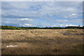
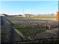
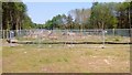
Currently open land at the end of The Cawsey
Formerly industrial or MOD land
Image: © Ian Greig
Taken: 7 Sep 2013
0.07 miles
2
Former gasworks site off Wateringpool Lane
This land has long been earmarked for development. In August 2015 planning permission was given for the building of 280 homes on the site: https://web.archive.org/web/20151229180207/http://www.leylandguardian.co.uk/news/local/former-gasworks-site-gets-the-go-ahead-for-280-new-homes-1-7411180
Image: © Adam C Snape
Taken: 27 Dec 2015
0.14 miles
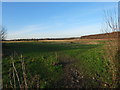
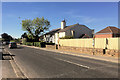
3
Currently open land at the end of The Cawsey
It looks to have previously been used for industrial buildings and is probably ear-marked for development.
Image: © Ian Greig
Taken: 7 Sep 2013
0.17 miles
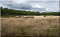
5
The gasometers have been dismantled
The last significant parts of the gasworks off Wateringpool Lane have been removed. Two large gas holding tanks stood in this location for many years. In August 2015 planning permission was given for the building of 280 homes on the former gasworks site: https://web.archive.org/web/20151229180207/http://www.leylandguardian.co.uk/news/local/former-gasworks-site-gets-the-go-ahead-for-280-new-homes-1-7411180
Image: © Adam C Snape
Taken: 27 Dec 2015
0.21 miles
8
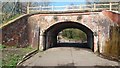
Leigh Brow Bridge
See Imagefor a view of the other side and for more information.
Image: © Paul Collins
Taken: 14 Apr 2018
0.25 miles
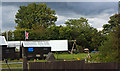
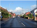
9
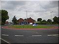
Roundabout on Leyland Road
This is the new roundabout on Leyland Road, at its junction with Bee Lane (to the left) and the new road, the Cawsey, to the right.
Image: © Mari Buckley
Taken: 5 Jul 2009
0.25 miles
10
Site of the new bridge
Looking east towards Carrwood Road from the route of the new link road. It can be seen that the trees surrounding the old railway have been cleared pending the construction of the new bridge.
See also: Image
Image: © Adam C Snape
Taken: 12 May 2016
0.25 miles