IMAGES TAKEN NEAR TO
Leyland Road, PRESTON, PR1 9QH
Introduction
This page details the photographs taken nearby to Leyland Road, PR1 9QH by members of the Geograph project.
The Geograph project started in 2005 with the aim of publishing, organising and preserving representative images for every square kilometre of Great Britain, Ireland and the Isle of Man.

There are currently over 7.5m images from over14,400 individuals and you can help contribute to the project by visiting https://www.geograph.org.uk
Image Map
Images are licensed for reuse under creativecommons.org/licenses/by-sa/2.0
Notes
- Clicking on the map will re-center to the selected point.
- The higher the marker number, the further away the image location is from the centre of the postcode.
Image Listing (53 Images Found)
Images are licensed for reuse under creativecommons.org/licenses/by-sa/2.0
Image
Details
Distance
7
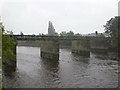
Pipe bridge
The stone piers are the remains of the viaduct, which brought the West Lancashire Railway over the River Ribble to West Lancashire Station which was situated on Beech Street, the station was closed in 1900. The piers are now used to carry a services pipe across the river.
Image: © Alexander P Kapp
Taken: 5 Sep 2009
0.10 miles
10
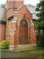
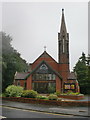
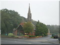
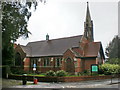
Penwortham Methodist Church, Porch
Image: © Alexander P Kapp
Taken: 5 Sep 2009
0.10 miles