IMAGES TAKEN NEAR TO
West Strand, PRESTON, PR1 8UJ
Introduction
This page details the photographs taken nearby to West Strand, PR1 8UJ by members of the Geograph project.
The Geograph project started in 2005 with the aim of publishing, organising and preserving representative images for every square kilometre of Great Britain, Ireland and the Isle of Man.

There are currently over 7.5m images from over14,400 individuals and you can help contribute to the project by visiting https://www.geograph.org.uk
Image Map
Images are licensed for reuse under creativecommons.org/licenses/by-sa/2.0
Notes
- Clicking on the map will re-center to the selected point.
- The higher the marker number, the further away the image location is from the centre of the postcode.
Image Listing (52 Images Found)
Images are licensed for reuse under creativecommons.org/licenses/by-sa/2.0
Image
Details
Distance
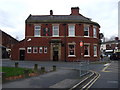
2
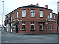
The Grand Junction Inn, Preston
On Water Lane.
Image: © JThomas
Taken: 15 Nov 2014
0.03 miles
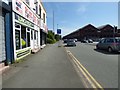
4
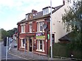
The Wheatsheaf on Water Lane Preston
Image: © Raymond Knapman
Taken: 2 Aug 2012
0.04 miles
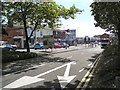
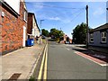
7
West Strand
The A5072 past the Alstom engineering works.
Image: © Gerald England
Taken: 18 Jul 2017
0.05 miles
8
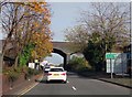
Water Lane in Preston
The railway from Preston to Blackpool runs over the bridge.
Image: © Steve Daniels
Taken: 30 Oct 2017
0.06 miles
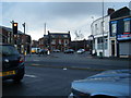
10
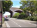
Fylde Road
The A583 into Preston crossing under the railway line from Blackpool.
Image: © Gerald England
Taken: 18 Jul 2017
0.07 miles