IMAGES TAKEN NEAR TO
Wellington Street, PRESTON, PR1 8TR
Introduction
This page details the photographs taken nearby to Wellington Street, PR1 8TR by members of the Geograph project.
The Geograph project started in 2005 with the aim of publishing, organising and preserving representative images for every square kilometre of Great Britain, Ireland and the Isle of Man.

There are currently over 7.5m images from over14,400 individuals and you can help contribute to the project by visiting https://www.geograph.org.uk
Image Map (Loading...)


Getting Data...Please wait
Leaflet Map data © OpenStreetMap
Images are licensed for reuse under creativecommons.org/licenses/by-sa/2.0
Notes
- Clicking on the map will re-center to the selected point.
- The higher the marker number, the further away the image location is from the centre of the postcode.
Image Listing (74 Images Found)
Images are licensed for reuse under creativecommons.org/licenses/by-sa/2.0
Image
Details
Distance
3
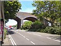
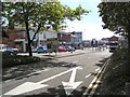
Fylde Road
The A583 into Preston crossing under the railway line from Blackpool.
Image: © Gerald England
Taken: 18 Jul 2017
0.05 miles
4
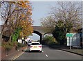
Water Lane in Preston
The railway from Preston to Blackpool runs over the bridge.
Image: © Steve Daniels
Taken: 30 Oct 2017
0.05 miles
6
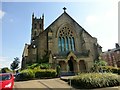
St Mark's Church, Preston
St Mark's Church, Preston, is a redundant Anglican parish church located in St Mark's Road, Preston, Lancashire, England. It is designated by English Heritage as a Grade II* listed building.
St Mark's was built in 1862–63 and designed by the Lancaster architect E. G. Paley. The cost of the church and the site was £6,594 (£530,000 as of 2013). The tower was added between 1868 and 1870. This is particularly tall because it was built to rival the very high steeple of the nearby Roman Catholic Church of St Walburge, which had been added to that church in 1867.
By the middle of the 20th century the population of St Mark's parish was declining, and the church was declared redundant on 1 December 1982. The building lay empty for over 10 years, and was then converted into residential flats. The altar and other furnishings were moved to St Michael and All Angels' Church, Ashton-on-Ribble, and installed in its Lady chapel, which was renamed St Mark's Chapel.
Image: © Rude Health
Taken: 26 Aug 2013
0.07 miles
7
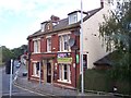
The Wheatsheaf on Water Lane Preston
Image: © Raymond Knapman
Taken: 2 Aug 2012
0.08 miles
9
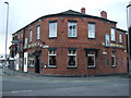
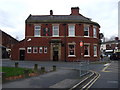
The Grand Junction Inn, Preston
On Water Lane.
Image: © JThomas
Taken: 15 Nov 2014
0.08 miles
10
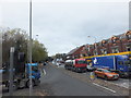
Tulketh Brow (the B6241)
From the junction with Water Lane (the A583).
Image: © Barbara Carr
Taken: 13 Nov 2013
0.09 miles