IMAGES TAKEN NEAR TO
Winckley Road, PRESTON, PR1 8EL
Introduction
This page details the photographs taken nearby to Winckley Road, PR1 8EL by members of the Geograph project.
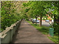
The Geograph project started in 2005 with the aim of publishing, organising and preserving representative images for every square kilometre of Great Britain, Ireland and the Isle of Man.

There are currently over 7.5m images from over14,400 individuals and you can help contribute to the project by visiting https://www.geograph.org.uk
Image Map
Images are licensed for reuse under creativecommons.org/licenses/by-sa/2.0
Notes
- Clicking on the map will re-center to the selected point.
- The higher the marker number, the further away the image location is from the centre of the postcode.
Image Listing (87 Images Found)
Images are licensed for reuse under creativecommons.org/licenses/by-sa/2.0
Image
Details
Distance
1
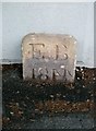
Old Boundary Marker by riverside wall, Broadgate, Preston Parish
Parish Boundary Marker by the Ribble Way, Broadgate, in parish of Preston (Preston District), Preston, behind MM opposite Meath Road.
Inscription reads:- : EB / 1844 :
Surveyed
Milestone Society National ID: LA_PSOK01pb.
Image: © Milestone Society
Taken: Unknown
0.07 miles
2
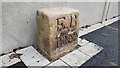
Old Boundary Marker by the riverside wall on Broadgate, Preston
Port of Preston Boundary Marker against the riverside wall on the west side of Broadgate in Preston opposite Meath Road and behind milestone LA_PSOK01. Inscribed L Q on its top and EB / 1844 on its front recording the Eastern Boundary of Legal Quay of the Port of Preston. See also https://www.geograph.org.uk/photo/6038958.
Milestone Society National ID: LA_PSOK01em
Image: © Ashley Warren Preston
Taken: 23 Dec 2023
0.07 miles
3
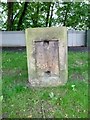
Old Milestone by Broadgate, Preston
Stone post (plate lost) by the UC road, in parish of PRESTON (PRESTON District), Broadgate, Preston; opposite No. 48 at Meath Road junction, by the road, on West side of road. Liverpool plate, erected by the Liverpool & Preston turnpike trust in the 19th century.
Inscription once read:-
(LIVERPOOL)
(30
(ORMSKIRK)
(17)
(PRESTON)
(1)
(Preston)
Milestone Society National ID: LA_PSOK01.
Image: © J Higgins
Taken: 1 Apr 2009
0.08 miles
4
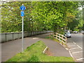
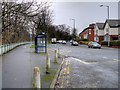
Guild Wheel opposite Ardee Road
The Guild Wheel path running along Broadgate, just opposite Ardee Road.
Image: © Steve Houldsworth
Taken: 13 May 2014
0.08 miles
5
Guild Wheel opposite Maresfield Road
Part of the Guild Wheel path running along Broadgate, just opposite Maresfield road.
Image: © Steve Houldsworth
Taken: 13 May 2014
0.10 miles
6

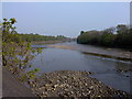
Low water on the Ribble
Between Broadgate and Penwortham.
Image: © John H Darch
Taken: 2 Nov 2014
0.11 miles
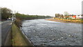
8

River Ribble
With New Bridge in the distance
Image: © Alexander P Kapp
Taken: 5 Sep 2009
0.12 miles
9
The River Ribble at Penwortham
Taken from the other side of the road from the Bridge Inn, after I'd taken the photos of the ghost sign. It's only mid-April, but we're in the middle of a heatwave!
Image: © Mari Buckley
Taken: 21 Apr 2011
0.13 miles
10
The River Ribble downstream from Penwortham Old Bridge
Image: © Colin Park
Taken: 14 Dec 2021
0.13 miles