IMAGES TAKEN NEAR TO
Basil Street, PRESTON, PR1 6XT
Introduction
This page details the photographs taken nearby to Basil Street, PR1 6XT by members of the Geograph project.
The Geograph project started in 2005 with the aim of publishing, organising and preserving representative images for every square kilometre of Great Britain, Ireland and the Isle of Man.

There are currently over 7.5m images from over14,400 individuals and you can help contribute to the project by visiting https://www.geograph.org.uk
Image Map
Images are licensed for reuse under creativecommons.org/licenses/by-sa/2.0
Notes
- Clicking on the map will re-center to the selected point.
- The higher the marker number, the further away the image location is from the centre of the postcode.
Image Listing (6 Images Found)
Images are licensed for reuse under creativecommons.org/licenses/by-sa/2.0
Image
Details
Distance
1
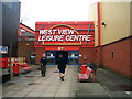
West View Leisure Centre
West View sports a very good climbing wall
Image: © Keith Wright
Taken: 14 Mar 2006
0.09 miles
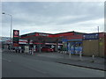
2
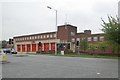
Preston fire station
Preston fire station, Blackpool Road, Preston, Lancashire.
Image: © Kevin Hale
Taken: 22 Oct 2006
0.17 miles
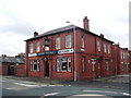
3
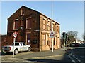
Old England Hotel, Ribbleton Lane, Preston
A disused former public house on Ribbleton Lane, Thorn Street junction. The Boddington's car park sign is a give away to its former use.
Image: © Rude Health
Taken: 18 Feb 2013
0.20 miles
6
The New Deepdale, St Georges Road, Preston
Image: © Alexander P Kapp
Taken: 6 Aug 2008
0.25 miles