IMAGES TAKEN NEAR TO
Ramsey Avenue, PRESTON, PR1 6EL
Introduction
This page details the photographs taken nearby to Ramsey Avenue, PR1 6EL by members of the Geograph project.
The Geograph project started in 2005 with the aim of publishing, organising and preserving representative images for every square kilometre of Great Britain, Ireland and the Isle of Man.

There are currently over 7.5m images from over14,400 individuals and you can help contribute to the project by visiting https://www.geograph.org.uk
Image Map
Images are licensed for reuse under creativecommons.org/licenses/by-sa/2.0
Notes
- Clicking on the map will re-center to the selected point.
- The higher the marker number, the further away the image location is from the centre of the postcode.
Image Listing (13 Images Found)
Images are licensed for reuse under creativecommons.org/licenses/by-sa/2.0
Image
Details
Distance
1
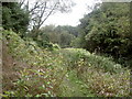
Eaves Brook
Japanese Knotweed and Himalayan Balsam in an uneasy truce. (Part of a circular walk around Preston – continues at Image)
Image: © Patrick
Taken: 9 Sep 2007
0.10 miles
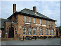
2
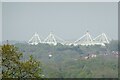
A view of Deepdale Stadium
From Goosefoot Lane in Hoghton. The stadium is the home of Preston North End football club.
Image: © philandju
Taken: 2 May 2024
0.16 miles
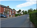
4
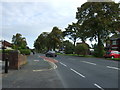
Watling Street Road, Fulwood
Looking north east.
Image: © JThomas
Taken: 1 Oct 2016
0.18 miles
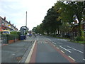
6
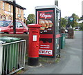
George VI postbox and telephone box on Watling Street Road.Preston
Postbox No. PR2 405.
Image: © JThomas
Taken: 1 Oct 2016
0.19 miles
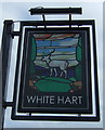
7
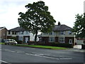
The White Hart, Fulwood
On Watling Street Road.
Image: © JThomas
Taken: 1 Oct 2016
0.19 miles
9
Bus stop and shelter on Watling Street Road, Fulwood
Image: © JThomas
Taken: 1 Oct 2016
0.22 miles
10
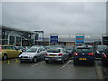
Deepdale Retail Park Carpark
In Preston not far from PNE's ground
Image: © Michael Graham
Taken: 26 Aug 2009
0.22 miles