IMAGES TAKEN NEAR TO
Charnock Fold, PRESTON, PR1 6BE
Introduction
This page details the photographs taken nearby to Charnock Fold, PR1 6BE by members of the Geograph project.
The Geograph project started in 2005 with the aim of publishing, organising and preserving representative images for every square kilometre of Great Britain, Ireland and the Isle of Man.

There are currently over 7.5m images from over14,400 individuals and you can help contribute to the project by visiting https://www.geograph.org.uk
Image Map (Loading...)


Getting Data...Please wait
Leaflet Map data © OpenStreetMap
Images are licensed for reuse under creativecommons.org/licenses/by-sa/2.0
Notes
- Clicking on the map will re-center to the selected point.
- The higher the marker number, the further away the image location is from the centre of the postcode.
Image Listing (11 Images Found)
Images are licensed for reuse under creativecommons.org/licenses/by-sa/2.0
Image
Details
Distance
2
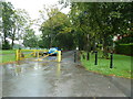
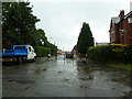
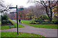
Moor Park Avenue, Preston
The gate is to stop through traffic between Deepdale Road and Garstang Road
Image: © Alexander P Kapp
Taken: 18 Sep 2012
0.08 miles
3
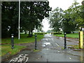
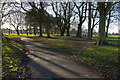
Footpath, Moor Park
Off Moor Park Avenue
Image: © Alexander P Kapp
Taken: 18 Sep 2012
0.08 miles
4
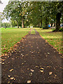
Moor Park
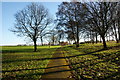
A lady walks her dogs along the southern side of Moor Park. Moor Park was created when Preston Council enclosed 100 acres of Preston Moor making it the first municipal park in the new industrial towns of north-west England. Improvements were carried out between 1862 and 1865 by garden designer Edward Milner using the labour of unemployed cotton workers.
Image: © Stephen McKay
Taken: 30 Nov 2022
0.10 miles
7
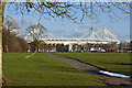
Looking towards Preston North End's ground at Deepdale in the adjoining square
Image: © Ian Greig
Taken: 7 Feb 2014
0.20 miles
8
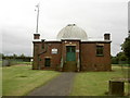
Jeremiah Horrocks Observatory, Moor Park
Jeremiah Horrocks (1618-1641) was an English astronomer who made the first observation of a transit of Venus. (He was from Toxteth in Liverpool, but lived near Preston after dropping out of Cambridge; he appears to have no connection to the eponymous dynasty of Preston cotton magnates.) The Observatory in Moor Park was built by Preston Council and opened on June 29th 1927, the day of a total solar eclipse. The new observatory lay in the path of totality and some 30,000 people thronged on Moor Park to witness the event. The main instrument in the observatory is an 8 inch Thomas Cooke Refractor, originally acquired for the Deepdale Observatory in 1912. The Observatory now belongs to the University of Central Lancashire, and is one of the 500 synoptic weather stations around the UK that forms the climatological network of the Met Office. (Sources: Wikipedia, Preston and District Astronomical Society, University of Central Lancashire.)
This picture forms part of a circular walk around Preston – continues at Image
Image: © Patrick
Taken: 9 Sep 2007
0.22 miles
9
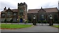
Moor Park Business and Enterprise School
The Moor Park Business and Enterprise School now occupies the buildings of Preston Grammar School. A campus of Preston College moved into the Park School buildings. The Sir Tom Finney Community High School is located near the Serpentine on Blackpool Road.
Image: © Rude Health
Taken: 28 Jul 2013
0.23 miles