IMAGES TAKEN NEAR TO
Warbury Street, PRESTON, PR1 4TR
Introduction
This page details the photographs taken nearby to Warbury Street, PR1 4TR by members of the Geograph project.
The Geograph project started in 2005 with the aim of publishing, organising and preserving representative images for every square kilometre of Great Britain, Ireland and the Isle of Man.

There are currently over 7.5m images from over14,400 individuals and you can help contribute to the project by visiting https://www.geograph.org.uk
Image Map (Loading...)


Getting Data...Please wait
Leaflet Map data © OpenStreetMap
Images are licensed for reuse under creativecommons.org/licenses/by-sa/2.0
Notes
- Clicking on the map will re-center to the selected point.
- The higher the marker number, the further away the image location is from the centre of the postcode.
Image Listing (29 Images Found)
Images are licensed for reuse under creativecommons.org/licenses/by-sa/2.0
Image
Details
Distance
5
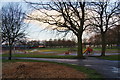
Ribbleton Park
All the play equipment is at this western end while playing fields occupy the areas towards Blackpool Road.
Image: © Bill Boaden
Taken: 18 Feb 2012
0.09 miles
6
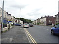
New Hall Lane (A59), Preston
Looking north east.
Image: © JThomas
Taken: 16 Jul 2016
0.10 miles