IMAGES TAKEN NEAR TO
Corporation Street, PRESTON, PR1 2UP
Introduction
This page details the photographs taken nearby to Corporation Street, PR1 2UP by members of the Geograph project.
The Geograph project started in 2005 with the aim of publishing, organising and preserving representative images for every square kilometre of Great Britain, Ireland and the Isle of Man.

There are currently over 7.5m images from over14,400 individuals and you can help contribute to the project by visiting https://www.geograph.org.uk
Image Map (Loading...)


Getting Data...Please wait
Leaflet Map data © OpenStreetMap
Images are licensed for reuse under creativecommons.org/licenses/by-sa/2.0
Notes
- Clicking on the map will re-center to the selected point.
- The higher the marker number, the further away the image location is from the centre of the postcode.
Image Listing (495 Images Found)
Images are licensed for reuse under creativecommons.org/licenses/by-sa/2.0
Image
Details
Distance
1
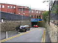
Fishergate Tunnel approach ramp, Preston
The Lancaster Canal was built in two parts connected only by a tramway because the canal company could not afford to build an aqueduct over the River Ribble. This tramway ran from the wharfs at the end of the northern section of the canal in Preston and passed under Fishergate, then part of the main east-west road through the town, in a tunnel and then ran via Avenham Park, a low-level bridge across the Ribble, and Bamber Bridge to the end of the southern section of the canal at Walton Summit. In the middle of the 19th century the canal was taken over by the London & North Western Railway and the tramway was taken out of use. The tunnel, which is at the foot of the ramp, was retained as an access to a railway goods yard alongside the passenger station. The alignment of the tunnel, pointing towards the canal terminus, is shown by the wall above the red car. The access ramp seen here, at an angle, was built when Corporation Street, behind the blue brick wall on the right, was driven through the area. The tunnel now forms an entrance to a shopping centre car park.
Image: © A-M-Jervis
Taken: 17 Aug 2007
0.02 miles
2
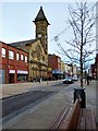
Looking from Fishergate into Corporation Street
Image: © Basher Eyre
Taken: 7 Apr 2018
0.02 miles

4
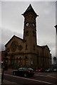
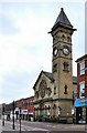
Fishergate Baptist Church, Preston
Image: © Alexander P Kapp
Taken: 26 Sep 2005
0.03 miles
5
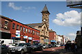
Fishergate Baptist Church, Preston
Although Baptists often worshipped in very simple surroundings, some Baptist churches, as here, were fine buildings. OS classes this as a church with tower, rather than spire.
Image: © Dr Neil Clifton
Taken: 2 May 2009
0.03 miles
6
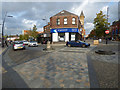
Corporation Street at Fishergate
Fishergate is on the right.
Image: © Thomas Nugent
Taken: 19 Oct 2018
0.03 miles
7
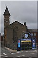
Fishergate Baptist Church
The rear view of the church behind the entrance to the Fishergate Shopping Centre. The latter is by way of a tunnel that was previously the entrance for road vehicles to the Lancashire and Yorkshire Railway's Butler Street Goods Depot, on the site of which the centre was built.
Image: © K A
Taken: 18 Jun 2011
0.03 miles
8
Fishergate Baptist Church, PR1 2UR
It comprises a purpose built place of worship, dating from around 1858 in stone with a slate roof and prominent steeple. Internally the upper floor is arranged as a worship area with the lower floor (accessed from Charnley Street) comprising a series of meeting rooms.
For sale for £500,000. The current Use Class for the church is an established D1 use which includes museums, art galleries, medical centres, surgeries and schools/nurseries.
Image: © Rude Health
Taken: 27 Oct 2012
0.03 miles
9
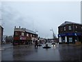
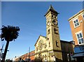
Preston, Fishergate
Fishergate is the main shopping street in Preston with the usual stores M&S, BHS, WH Smiths etc.
Since 2014, the area has been designated as 'Shared space'; an urban design approach which reduces the markings separating vehicles and pedestrians which involves removing kerbs and traffic signs to produce a more open space with widened pavements incorporating trees (http://www.preston.gov.uk/yourservices/transport-and-parking/roads-and-pavements/fishergate-central-gateway-project/ Fishergate Central Gateway project, Preston City Council). Neither cars nor pedestrians have right of way and it has been claimed, by “traffic experts”, that this makes the road safer as drivers have to stay on their guard (http://www.blogpreston.co.uk/2014/10/seven-things-you-said-on-fishergate-new-layout-completion/ Blog Preston).
The building with the tower is the former Fishergate Baptist Church. Built in 1857-58, the church was declared redundant in 2011 and is currently for sale. It is a Grade II listed building (English Heritage Building ID: 391987 http://www.britishlistedbuildings.co.uk/en-391987-fishergate-baptist-church-lancashire British Listed Buildings).
Image: © David Dixon
Taken: 14 Jan 2015
0.03 miles