IMAGES TAKEN NEAR TO
St. Pauls Road, PRESTON, PR1 1UE
Introduction
This page details the photographs taken nearby to St. Pauls Road, PR1 1UE by members of the Geograph project.
The Geograph project started in 2005 with the aim of publishing, organising and preserving representative images for every square kilometre of Great Britain, Ireland and the Isle of Man.

There are currently over 7.5m images from over14,400 individuals and you can help contribute to the project by visiting https://www.geograph.org.uk
Image Map (Loading...)


Getting Data...Please wait
Leaflet Map data © OpenStreetMap
Images are licensed for reuse under creativecommons.org/licenses/by-sa/2.0
Notes
- Clicking on the map will re-center to the selected point.
- The higher the marker number, the further away the image location is from the centre of the postcode.
Image Listing (70 Images Found)
Images are licensed for reuse under creativecommons.org/licenses/by-sa/2.0
Image
Details
Distance
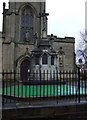
1
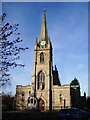
St Ignatius' Roman Catholic Church, Preston
Image: © Alexander P Kapp
Taken: 14 Nov 2007
0.07 miles
3
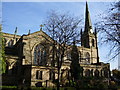
St Ignatius' Roman Catholic Church, Preston
Image: © Alexander P Kapp
Taken: 14 Nov 2007
0.07 miles
6
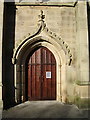
St Ignatius' Roman Catholic Church, Preston, Doorway
Image: © Alexander P Kapp
Taken: 14 Nov 2007
0.07 miles
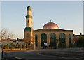
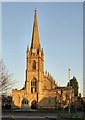
9
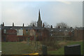
St Ignatius RC Church spire, from the A6
As seen from the saloon of the no.40 Morecambe-Preston bus.
Image: © David Long
Taken: 30 Dec 2008
0.09 miles
10
St Ignatius' Square, Preston
http://www.preston.gov.uk/Documents/General/Planning/Conseravtion/St%20Ignatius%20Conservation%20Area%20Appraisal.pdf
Image: © Alexander P Kapp
Taken: 14 Nov 2007
0.09 miles