IMAGES TAKEN NEAR TO
Brookfield Street, PRESTON, PR1 1NR
Introduction
This page details the photographs taken nearby to Brookfield Street, PR1 1NR by members of the Geograph project.
The Geograph project started in 2005 with the aim of publishing, organising and preserving representative images for every square kilometre of Great Britain, Ireland and the Isle of Man.

There are currently over 7.5m images from over14,400 individuals and you can help contribute to the project by visiting https://www.geograph.org.uk
Image Map
Images are licensed for reuse under creativecommons.org/licenses/by-sa/2.0
Notes
- Clicking on the map will re-center to the selected point.
- The higher the marker number, the further away the image location is from the centre of the postcode.
Image Listing (34 Images Found)
Images are licensed for reuse under creativecommons.org/licenses/by-sa/2.0
Image
Details
Distance
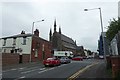
4
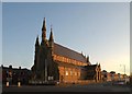
St. Thomas of Canterbury
St. Thomas of Canterbury Preston
Image: © Galatas
Taken: 10 Feb 2008
0.14 miles
5
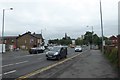
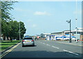
Garstang Road
Looking along Garstang Road near North Road and Moor Lane.
Image: © DS Pugh
Taken: 23 Jul 2018
0.14 miles
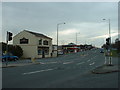
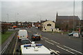
8
Approaching Garstang Road
Aqueduct Street meets Garstang Road with St. Thomas of Canterbury Church on the corner.
Image: © DS Pugh
Taken: 23 Jul 2018
0.15 miles
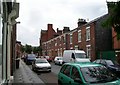
10
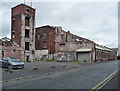
Former Hanover Street Mill, Kent Street, Preston
Former cotton mill, dated c1825. Despite this, and its listing, partly demolished at the time, the remainder standing idle. Grade II listed.
Image: © Stephen Richards
Taken: 12 Jun 2013
0.16 miles