IMAGES TAKEN NEAR TO
Bishopgate, PRESTON, PR1 1AT
Introduction
This page details the photographs taken nearby to Bishopgate, PR1 1AT by members of the Geograph project.
The Geograph project started in 2005 with the aim of publishing, organising and preserving representative images for every square kilometre of Great Britain, Ireland and the Isle of Man.

There are currently over 7.5m images from over14,400 individuals and you can help contribute to the project by visiting https://www.geograph.org.uk
Image Map
Images are licensed for reuse under creativecommons.org/licenses/by-sa/2.0
Notes
- Clicking on the map will re-center to the selected point.
- The higher the marker number, the further away the image location is from the centre of the postcode.
Image Listing (295 Images Found)
Images are licensed for reuse under creativecommons.org/licenses/by-sa/2.0
Image
Details
Distance
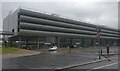
1
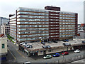
Preston Office Centre, Lancaster Road, Preston
One of a number of large post-war developments surrounding the bus station like satellites. Three large 1960s slabs, two running perpendicular to, and behind, the facing block. They enclose a car park, hidden away, unlike the probably contemporary one in front which is rather an eyesore.
Image: © Stephen Richards
Taken: 11 Jun 2013
0.02 miles
2
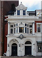
Detail of Sheraton House, Ormskirk Road, Preston
The west end has a pair of arched entrances, oriel and gabled dormer. A sort of Baroque Arts and Crafts style perhaps.
Image: © Stephen Richards
Taken: 11 Jun 2013
0.03 miles
3

Victoria House, Preston
Office block on Ormskirk Road.
Image: © JThomas
Taken: 16 Jul 2016
0.04 miles
4
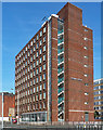
Victoria House, Ringway, Preston
Brick clad office block, dating from the late 1960s or early 1970s when the city seems to have experienced a minor building boom.
Image: © Stephen Richards
Taken: 11 Jun 2013
0.04 miles
6
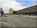
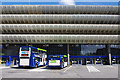
Preston Bus Station, Tithebarn Street
Preston Bus Station was built in 1968 in the Brutalist architectural style. It was threatened with demolition as part of the City Council's Tithebarn redevelopment https://en.wikipedia.org/wiki/Preston_Tithebarn_redevelopment but there was public opposition to the plans. After two failed attempts it was granted Grade II listed building status in 2013.
The station has a capacity for 80 double-decker buses, 40 along each side of the building. It incorporates a five floor multi-storey car park with space for 1100 cars. Access to the town centre is via three subways.
Ownership has now passed to Lancashire County Council, whose refurbishment plans include a new youth centre at the far end of the forecourt.
Image: © Gerald England
Taken: 28 Aug 2016
0.04 miles
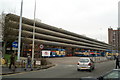
7
Preston Bus Station
Built in the Brutalist architectural style between 1968 and 1969. It was granted Grade II listed building status in September 2013.
Image: © Mat Fascione
Taken: 16 Sep 2018
0.05 miles
8
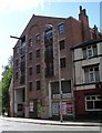
Lancastria House, Lancaster Road, Preston
Built for the Co-op by company architect W.A. Johnson.
At the time the ground floor was occupied by a Chinese restaurant, Great Times. The building appears to face an uncertain future due to a possible redevelopment scheme.
Image: © Stephen Richards
Taken: 11 Jun 2013
0.05 miles
9
Proud Preston's own
At Preston bus station the local Borough's buses have the side closest to the town to themselves. Other operators use the ranks on the other side of the building.
Image: © David Long
Taken: 23 Dec 2008
0.05 miles
10
Preston Bus Station
Built in 1968-9 and due to be demolished, on the grounds that it is too large (80 stands). Attempts to have the building listed have failed, but there is still a campaign to save it. There is a multi-storey car park above.
See http://en.wikipedia.org/wiki/Preston_bus_station .
Image: © Ian Taylor
Taken: 26 Aug 2012
0.05 miles