IMAGES TAKEN NEAR TO
Danesway, PRESTON, PR1 0TH
Introduction
This page details the photographs taken nearby to Danesway, PR1 0TH by members of the Geograph project.
The Geograph project started in 2005 with the aim of publishing, organising and preserving representative images for every square kilometre of Great Britain, Ireland and the Isle of Man.

There are currently over 7.5m images from over14,400 individuals and you can help contribute to the project by visiting https://www.geograph.org.uk
Image Map (Loading...)


Getting Data...Please wait
Leaflet Map data © OpenStreetMap
Images are licensed for reuse under creativecommons.org/licenses/by-sa/2.0
Notes
- Clicking on the map will re-center to the selected point.
- The higher the marker number, the further away the image location is from the centre of the postcode.
Image Listing (9 Images Found)
Images are licensed for reuse under creativecommons.org/licenses/by-sa/2.0
Image
Details
Distance
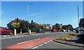
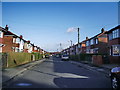
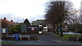
1
Clovelly Drive / Newlands Avenue - Penwortham
Image: © Anthony Parkes
Taken: 17 May 2014
0.04 miles
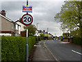
4
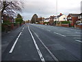
Liverpool Road (A59)
Heading north east towards Preston.
Image: © JThomas
Taken: 22 Nov 2014
0.15 miles
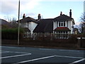
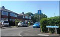
6
United Reformed Church, Penwortham
Liverpool Road. Home to one of the biggest Scout Groups in the region, 5th Penwortham.
Image: © Dave Shaw
Taken: 26 Dec 2008
0.21 miles
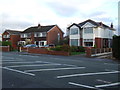
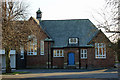
8
United Reformed Church, Higher Penwortham
On Liverpool Road (A59).
Image: © JThomas
Taken: 22 Nov 2014
0.23 miles