IMAGES TAKEN NEAR TO
Mayflower Avenue, PRESTON, PR1 0LJ
Introduction
This page details the photographs taken nearby to Mayflower Avenue, PR1 0LJ by members of the Geograph project.
The Geograph project started in 2005 with the aim of publishing, organising and preserving representative images for every square kilometre of Great Britain, Ireland and the Isle of Man.

There are currently over 7.5m images from over14,400 individuals and you can help contribute to the project by visiting https://www.geograph.org.uk
Image Map (Loading...)


Getting Data...Please wait
Leaflet Map data © OpenStreetMap
Images are licensed for reuse under creativecommons.org/licenses/by-sa/2.0
Notes
- Clicking on the map will re-center to the selected point.
- The higher the marker number, the further away the image location is from the centre of the postcode.
Image Listing (6 Images Found)
Images are licensed for reuse under creativecommons.org/licenses/by-sa/2.0
Image
Details
Distance
1
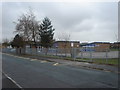
Whitefield Primary School
Nothing around this area on the 1940's map, but now surrounded by housing.
Image: © Margaret Clough
Taken: 27 Mar 2006
0.04 miles
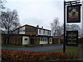
3
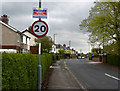
Junction of A59 and Central Drive, Hutton, Lancashire
Image: © nick macneill
Taken: 1 Sep 2011
0.21 miles
5
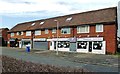
Shops In Penwortham
Located at the end of Howick Park Avenue, these businesses cater for events such as weddings. They include a hat hire service, a baker of wedding cakes and a barber as well as a creative hair and beauty service.
Image: © Mary and Angus Hogg
Taken: 18 Feb 2019
0.21 miles