IMAGES TAKEN NEAR TO
Blackcap Close, ROWLAND'S CASTLE, PO9 6HD
Introduction
This page details the photographs taken nearby to Blackcap Close, PO9 6HD by members of the Geograph project.
The Geograph project started in 2005 with the aim of publishing, organising and preserving representative images for every square kilometre of Great Britain, Ireland and the Isle of Man.

There are currently over 7.5m images from over14,400 individuals and you can help contribute to the project by visiting https://www.geograph.org.uk
Image Map
Images are licensed for reuse under creativecommons.org/licenses/by-sa/2.0
Notes
- Clicking on the map will re-center to the selected point.
- The higher the marker number, the further away the image location is from the centre of the postcode.
Image Listing (139 Images Found)
Images are licensed for reuse under creativecommons.org/licenses/by-sa/2.0
Image
Details
Distance
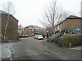
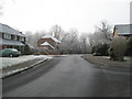
1
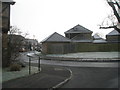
Junction of Mallard Road and Blackcap Close
Image: © Basher Eyre
Taken: 10 Jan 2009
0.03 miles
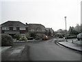
2
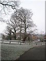
Looking across to Nightingale Close from path just past Kingfisher Close
Image: © Basher Eyre
Taken: 10 Jan 2009
0.04 miles
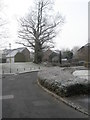
3
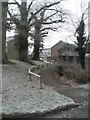
Path from Nightingale Close to Blackgap Close
Image: © Basher Eyre
Taken: 10 Jan 2009
0.05 miles
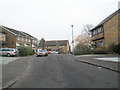
4
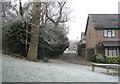
Path through the housing estate at Redhill
Image: © Basher Eyre
Taken: 10 Jan 2009
0.06 miles
6
Looking from Mallard Road towards Brambling Road
Image: © Basher Eyre
Taken: 10 Jan 2009
0.07 miles
9
Looking towards the junction of Mallard Road and Manor Lodge Road
Image: © Basher Eyre
Taken: 10 Jan 2009
0.08 miles
10
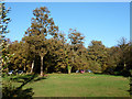
By the car park, Havant Thicket
Forestry Commission woodland, very popular with Sunday afternoon strollers.
Image: © Robin Webster
Taken: 10 Nov 2013
0.09 miles