IMAGES TAKEN NEAR TO
Durrants Road, ROWLAND'S CASTLE, PO9 6BE
Introduction
This page details the photographs taken nearby to Durrants Road, PO9 6BE by members of the Geograph project.
The Geograph project started in 2005 with the aim of publishing, organising and preserving representative images for every square kilometre of Great Britain, Ireland and the Isle of Man.

There are currently over 7.5m images from over14,400 individuals and you can help contribute to the project by visiting https://www.geograph.org.uk
Image Map
Images are licensed for reuse under creativecommons.org/licenses/by-sa/2.0
Notes
- Clicking on the map will re-center to the selected point.
- The higher the marker number, the further away the image location is from the centre of the postcode.
Image Listing (79 Images Found)
Images are licensed for reuse under creativecommons.org/licenses/by-sa/2.0
Image
Details
Distance
1
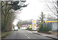
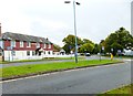
Shell garage on B2149 at Rowlands Castle
Image: © John Firth
Taken: 15 Apr 2013
0.08 miles
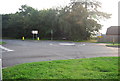
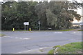
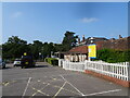
3
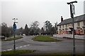
Pub and road junction, Rowlands Castle
Image: © Martyn Pattison
Taken: 14 Jan 2006
0.13 miles
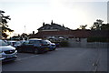
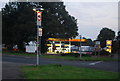
8
The Harvester PH on Manor Lodge Road
This was the subject of the first geograph for this gridsquare in 2006 - see http://www.geograph.org.uk/photo/105412.
Image: © Shazz
Taken: 11 Oct 2014
0.15 miles
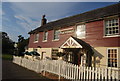
9
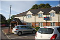
Harvester Pub
The view of the Rowlands Castle Pub.
Image: © Gordon Griffiths
Taken: 3 Sep 2021
0.15 miles