IMAGES TAKEN NEAR TO
The Peak, ROWLAND'S CASTLE, PO9 6AH
Introduction
This page details the photographs taken nearby to The Peak, PO9 6AH by members of the Geograph project.
The Geograph project started in 2005 with the aim of publishing, organising and preserving representative images for every square kilometre of Great Britain, Ireland and the Isle of Man.

There are currently over 7.5m images from over14,400 individuals and you can help contribute to the project by visiting https://www.geograph.org.uk
Image Map (Loading...)


Getting Data...Please wait
Leaflet Map data © OpenStreetMap
Images are licensed for reuse under creativecommons.org/licenses/by-sa/2.0
Notes
- Clicking on the map will re-center to the selected point.
- The higher the marker number, the further away the image location is from the centre of the postcode.
Image Listing (200 Images Found)
Images are licensed for reuse under creativecommons.org/licenses/by-sa/2.0
Image
Details
Distance
1

Looking from Bowes Hill into Greatfield Way
Image: © Basher Eyre
Taken: 1 Apr 2009
0.09 miles
2

Approaching the junction of Bowes Hill and Greatfield Way
Image: © Basher Eyre
Taken: 1 Apr 2009
0.10 miles


6
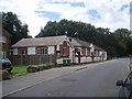
Rowlands Castle Village Hall
An interesting building at the entrance to "The Green".
Image: © Basher Eyre
Taken: 6 Aug 2007
0.13 miles
7
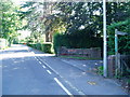
The Monarch's Way
The route continues south along Bowes Hill towards of Rowlands Castle.
Image: © Peter Holmes
Taken: 23 Aug 2008
0.14 miles
8

The Fountain Inn, Rowlands Castle
The overlooks the village green.
Image: © Maigheach-gheal
Taken: 11 May 2008
0.14 miles

10

Sign for the Fountain Inn, Rowlands Castle
This sign is frequently found on Roman roads or where there was a spring.
Image: © Maigheach-gheal
Taken: 11 May 2008
0.14 miles