IMAGES TAKEN NEAR TO
Dunsbury Way, HAVANT, PO9 5BG
Introduction
This page details the photographs taken nearby to Dunsbury Way, PO9 5BG by members of the Geograph project.
The Geograph project started in 2005 with the aim of publishing, organising and preserving representative images for every square kilometre of Great Britain, Ireland and the Isle of Man.

There are currently over 7.5m images from over14,400 individuals and you can help contribute to the project by visiting https://www.geograph.org.uk
Image Map
Images are licensed for reuse under creativecommons.org/licenses/by-sa/2.0
Notes
- Clicking on the map will re-center to the selected point.
- The higher the marker number, the further away the image location is from the centre of the postcode.
Image Listing (180 Images Found)
Images are licensed for reuse under creativecommons.org/licenses/by-sa/2.0
Image
Details
Distance
3
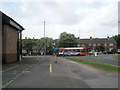
Looking from Bishopstoke Road down to Dunsbury Way
Image: © Basher Eyre
Taken: 16 May 2009
0.02 miles
4
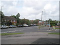
Junction of Dunsbury Way and Bishopstoke Road
Image: © Basher Eyre
Taken: 16 May 2009
0.02 miles
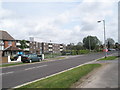
6
Open Space in Bishopstoke Road
Taken on week three of the Havant Borough Council May Day Arts Trail.
Image: © Basher Eyre
Taken: 16 May 2009
0.03 miles
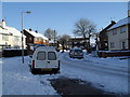
7
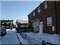
Looking from Dunsbury Way across to a snowy Ellisfield Road
Image: © Basher Eyre
Taken: 9 Jan 2010
0.03 miles
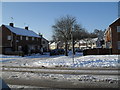
8

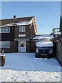
Approaching the junction of Ellisfield Road and Dunsbury Way
Image: © Basher Eyre
Taken: 9 Jan 2010
0.03 miles
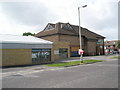
10
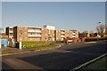
Tyler court, Bishopstoke Road, Havant
These are flats. This road leads to a car park behind Greywell Shopping Centre.
Image: © Peter Facey
Taken: 21 Jan 2009
0.03 miles