IMAGES TAKEN NEAR TO
St. Albans Road, HAVANT, PO9 2JP
Introduction
This page details the photographs taken nearby to St. Albans Road, PO9 2JP by members of the Geograph project.
The Geograph project started in 2005 with the aim of publishing, organising and preserving representative images for every square kilometre of Great Britain, Ireland and the Isle of Man.

There are currently over 7.5m images from over14,400 individuals and you can help contribute to the project by visiting https://www.geograph.org.uk
Image Map
Images are licensed for reuse under creativecommons.org/licenses/by-sa/2.0
Notes
- Clicking on the map will re-center to the selected point.
- The higher the marker number, the further away the image location is from the centre of the postcode.
Image Listing (125 Images Found)
Images are licensed for reuse under creativecommons.org/licenses/by-sa/2.0
Image
Details
Distance
1
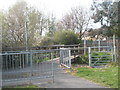
Bridge from New Road over to Flexford Gardens
Image: © Basher Eyre
Taken: 3 Apr 2009
0.06 miles
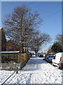
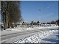
2
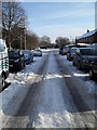
Treacherous conditions in Lockersley Road
Image: © Basher Eyre
Taken: 9 Jan 2010
0.06 miles
4
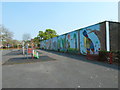
Mural within a playpark in St Alban's Road
Image: © Basher Eyre
Taken: 17 Apr 2011
0.07 miles
6
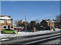
Looking from Crossland Drive towards Chichester House
Image: © Basher Eyre
Taken: 9 Jan 2010
0.07 miles
7
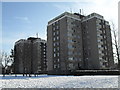
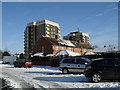
Tower blocks in Lockersley Road
A friend of mine lived on the 7th floor of the one nearest camera for many years. She loved it.
Image: © Basher Eyre
Taken: 9 Jan 2010
0.08 miles
8
Looking from Hipley Road towards Chichester House and Langstone House
Image: © Basher Eyre
Taken: 9 Jan 2010
0.08 miles
9
Looking over from Lavant Drive towards the towerblocks in Lockersley Road
Image: © Basher Eyre
Taken: 9 Jan 2010
0.08 miles