IMAGES TAKEN NEAR TO
Meadow Rise, WATERLOOVILLE, PO8 9AB
Introduction
This page details the photographs taken nearby to Meadow Rise, PO8 9AB by members of the Geograph project.
The Geograph project started in 2005 with the aim of publishing, organising and preserving representative images for every square kilometre of Great Britain, Ireland and the Isle of Man.

There are currently over 7.5m images from over14,400 individuals and you can help contribute to the project by visiting https://www.geograph.org.uk
Image Map
Images are licensed for reuse under creativecommons.org/licenses/by-sa/2.0
Notes
- Clicking on the map will re-center to the selected point.
- The higher the marker number, the further away the image location is from the centre of the postcode.
Image Listing (89 Images Found)
Images are licensed for reuse under creativecommons.org/licenses/by-sa/2.0
Image
Details
Distance
1
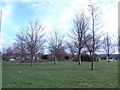
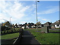
Greenspace
A small triangular area amid a mass of sprawling 1960's housing.
Image: © Jonathan Billinger
Taken: 2 Mar 2007
0.05 miles
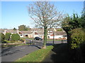
2
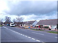
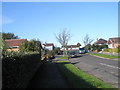
Bungalowsville
Quite a lot of them in Cowplain!
Image: © Jonathan Billinger
Taken: 2 Mar 2007
0.07 miles
3

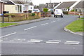
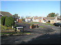
Junction of Greenfield Rise and Greenfield Crescent
Image: © Basher Eyre
Taken: 7 Nov 2009
0.09 miles
4
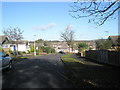
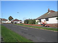
Looking from Erica Way into Hazleton Way
Image: © Basher Eyre
Taken: 7 Nov 2009
0.09 miles
6
Looking from Greenfield Rise into Greenfield Crescent
Image: © Basher Eyre
Taken: 7 Nov 2009
0.10 miles
8
Approaching the junction of Greenfield Crescent and Greenfield Rise
Image: © Basher Eyre
Taken: 7 Nov 2009
0.11 miles