IMAGES TAKEN NEAR TO
Hart Plain Avenue, WATERLOOVILLE, PO8 8PW
Introduction
This page details the photographs taken nearby to Hart Plain Avenue, PO8 8PW by members of the Geograph project.
The Geograph project started in 2005 with the aim of publishing, organising and preserving representative images for every square kilometre of Great Britain, Ireland and the Isle of Man.

There are currently over 7.5m images from over14,400 individuals and you can help contribute to the project by visiting https://www.geograph.org.uk
Image Map
Images are licensed for reuse under creativecommons.org/licenses/by-sa/2.0
Notes
- Clicking on the map will re-center to the selected point.
- The higher the marker number, the further away the image location is from the centre of the postcode.
Image Listing (11 Images Found)
Images are licensed for reuse under creativecommons.org/licenses/by-sa/2.0
Image
Details
Distance
2
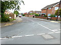
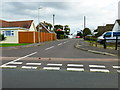
Looking into Bridefield Crescent
It's not crescent-shaped.
Image: © Shazz
Taken: 25 Oct 2014
0.14 miles
6
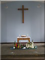
Display within Hart Plain Church
Just one of the attractions on the last week-end of Havant Borough Council's May Day Art Trail.
Image: © Basher Eyre
Taken: 16 May 2009
0.21 miles
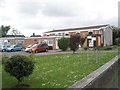
8
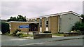
Hart Plain Church
Modern building shared by the Church of England and the Methodists.
Image: © Michael FORD
Taken: Unknown
0.21 miles
9

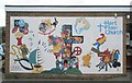
Art exhibits within Hart Plain Church
Just one of the attractions on the last week-end of Havant Borough Council's May Day Art Trail.
Image: © Basher Eyre
Taken: 16 May 2009
0.21 miles
10
Hart Plain Church
It is a rare joint Methodist and Anglican Church.
Image: © Basher Eyre
Taken: 16 May 2009
0.22 miles