IMAGES TAKEN NEAR TO
Tamworth Road, WATERLOOVILLE, PO7 7EJ
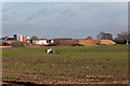
Introduction
This page details the photographs taken nearby to Tamworth Road, PO7 7EJ by members of the Geograph project.
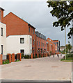
The Geograph project started in 2005 with the aim of publishing, organising and preserving representative images for every square kilometre of Great Britain, Ireland and the Isle of Man.

There are currently over 7.5m images from over14,400 individuals and you can help contribute to the project by visiting https://www.geograph.org.uk
Image Map
Images are licensed for reuse under creativecommons.org/licenses/by-sa/2.0
Notes
- Clicking on the map will re-center to the selected point.
- The higher the marker number, the further away the image location is from the centre of the postcode.
Image Listing (60 Images Found)
Images are licensed for reuse under creativecommons.org/licenses/by-sa/2.0
Image
Details
Distance
1
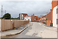
Coulter Road
The left side not yet developed.
Image: © Peter Facey
Taken: 5 Sep 2011
0.06 miles
2
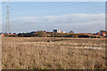
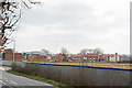
West of Waterlooville housing development
I think it is Wellington Park at left, Dukes Meadow at right.
Image: © Peter Facey
Taken: 17 Dec 2011
0.06 miles
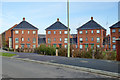
3
New housing in Coulter Road
Part of the Dukes Meadow or Wellington Park developments.
Image: © Peter Facey
Taken: 5 Sep 2011
0.08 miles
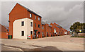
4
Houses, Wellington Park, Waterlooville
A fairly new estate expanding Waterlooville to the west.
Image: © Robin Webster
Taken: 17 Nov 2019
0.08 miles
5
West of Waterlooville housing development site
The red house at right is Image New drainage culverts can be seen in the foreground. Seen from footpath.
Image: © Peter Facey
Taken: 17 Dec 2011
0.09 miles
6
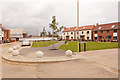
New Housing in Coulter Road
With Dibber Road being the first turning left, and Sickle Way being beyond the bollards. The street names in this new development are named after agricultural implements. At time of photographing this housing was partly occupied.
Image: © Peter Facey
Taken: 5 Sep 2011
0.10 miles
7
Dukes Meadow development
The part of this large, "West of Waterlooville" development site that has laready been built, is named Dukes Meadow. See Image Here it is seen looking across Hambledon Road and a site not yet built.
Image: © Peter Facey
Taken: 21 Mar 2010
0.10 miles
8
New green and housing in Dibber Road
Part of the Wellington Park development.
Image: © Peter Facey
Taken: 5 Sep 2011
0.12 miles
9
West of Waterlooville housing developments
Seen from footpath. I think that Wellington Park is on the left and the slightly earlier Dukes Meadow on the right.
Image: © Peter Facey
Taken: 17 Dec 2011
0.14 miles
10
West of Waterlooville housing development
Seen from footpath.
Image: © Peter Facey
Taken: 17 Dec 2011
0.14 miles