IMAGES TAKEN NEAR TO
Mill Close, WATERLOOVILLE, PO7 6PE
Introduction
This page details the photographs taken nearby to Mill Close, PO7 6PE by members of the Geograph project.
The Geograph project started in 2005 with the aim of publishing, organising and preserving representative images for every square kilometre of Great Britain, Ireland and the Isle of Man.

There are currently over 7.5m images from over14,400 individuals and you can help contribute to the project by visiting https://www.geograph.org.uk
Image Map
Images are licensed for reuse under creativecommons.org/licenses/by-sa/2.0
Notes
- Clicking on the map will re-center to the selected point.
- The higher the marker number, the further away the image location is from the centre of the postcode.
Image Listing (3 Images Found)
Images are licensed for reuse under creativecommons.org/licenses/by-sa/2.0
Image
Details
Distance
1
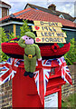
Denmead celebrates 1944
During the approach to D-Day, Allied troops under US General Eisenhower were concealed in the woods to the west of Denmead, preparing for embarkation to Normandy. The British Government went to great lengths to disguise the size of our forces and to convince the Nazis that the invasion of Europe would be launched from Dover.
By reverse co-incidence, adjacent Waterlooville was the place where British soldiers halted in 1815 on their return from France, having defeated Napoleon: some went no further and settled permanently in the area.
Image: © Clare Burke
Taken: 6 Jun 2024
0.17 miles
3
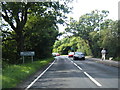
Hambledon Road and Denmead boundary sign
Image: © Colin Pyle
Taken: 11 Aug 2012
0.23 miles