IMAGES TAKEN NEAR TO
Southwick Road, WATERLOOVILLE, PO7 6LB
Introduction
This page details the photographs taken nearby to Southwick Road, PO7 6LB by members of the Geograph project.
The Geograph project started in 2005 with the aim of publishing, organising and preserving representative images for every square kilometre of Great Britain, Ireland and the Isle of Man.

There are currently over 7.5m images from over14,400 individuals and you can help contribute to the project by visiting https://www.geograph.org.uk
Image Map
Images are licensed for reuse under creativecommons.org/licenses/by-sa/2.0
Notes
- Clicking on the map will re-center to the selected point.
- The higher the marker number, the further away the image location is from the centre of the postcode.
Image Listing (62 Images Found)
Images are licensed for reuse under creativecommons.org/licenses/by-sa/2.0
Image
Details
Distance
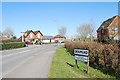
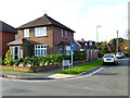
3
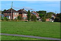
Recreation ground beside Southwick Road
Image: © David Martin
Taken: 18 Oct 2018
0.02 miles
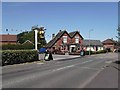
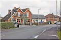
4
"The Harvest Home" PH
The first geograph for this square is of the same subject at http://www.geograph.org.uk/photo/1599817.
Image: © Shazz
Taken: 27 Oct 2014
0.03 miles
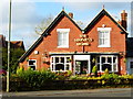
5
Harvest Home pub, Southwick Road, Denmead
Image: © Peter Facey
Taken: 27 Mar 2008
0.03 miles
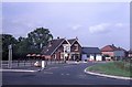
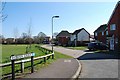
7
Looking into Harvest Road
A similar view is at http://www.geograph.org.uk/photo/2342574.
Image: © Shazz
Taken: 27 Oct 2014
0.03 miles
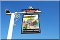
8
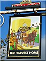
Sign at "The Harvest Home" PH
It's just the same as in 2011. See http://www.geograph.org.uk/photo/2342508.
Image: © Shazz
Taken: 27 Oct 2014
0.03 miles