IMAGES TAKEN NEAR TO
London Road, WATERLOOVILLE, PO7 5EW
Introduction
This page details the photographs taken nearby to London Road, PO7 5EW by members of the Geograph project.
The Geograph project started in 2005 with the aim of publishing, organising and preserving representative images for every square kilometre of Great Britain, Ireland and the Isle of Man.

There are currently over 7.5m images from over14,400 individuals and you can help contribute to the project by visiting https://www.geograph.org.uk
Image Map
Images are licensed for reuse under creativecommons.org/licenses/by-sa/2.0
Notes
- Clicking on the map will re-center to the selected point.
- The higher the marker number, the further away the image location is from the centre of the postcode.
Image Listing (120 Images Found)
Images are licensed for reuse under creativecommons.org/licenses/by-sa/2.0
Image
Details
Distance
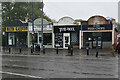
2
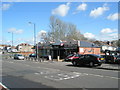
Small row of shops by the Purbrook Heath roundabout
Image: © Basher Eyre
Taken: 21 Mar 2008
0.04 miles
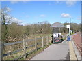
4
An inviting offer at Purbrook Heath Farm
Image: © Basher Eyre
Taken: 21 Mar 2008
0.05 miles

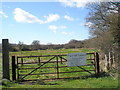
7
Gas installation opposite Park Road, Purbrook
Image: © Basher Eyre
Taken: 21 Mar 2008
0.07 miles