IMAGES TAKEN NEAR TO
Holywell Drive, PORTSMOUTH, PO6 4TB
Introduction
This page details the photographs taken nearby to Holywell Drive, PO6 4TB by members of the Geograph project.
The Geograph project started in 2005 with the aim of publishing, organising and preserving representative images for every square kilometre of Great Britain, Ireland and the Isle of Man.

There are currently over 7.5m images from over14,400 individuals and you can help contribute to the project by visiting https://www.geograph.org.uk
Image Map
Images are licensed for reuse under creativecommons.org/licenses/by-sa/2.0
Notes
- Clicking on the map will re-center to the selected point.
- The higher the marker number, the further away the image location is from the centre of the postcode.
Image Listing (146 Images Found)
Images are licensed for reuse under creativecommons.org/licenses/by-sa/2.0
Image
Details
Distance
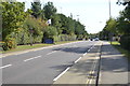
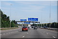
4
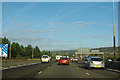
Westbound M27
A slip road from a short motorway spur from the Cosham area, also deemed part of the M27, merges at the left.
Image: © Robin Webster
Taken: 30 Oct 2012
0.05 miles