IMAGES TAKEN NEAR TO
Kelsey Head, PORTSMOUTH, PO6 4TA
Introduction
This page details the photographs taken nearby to Kelsey Head, PO6 4TA by members of the Geograph project.
The Geograph project started in 2005 with the aim of publishing, organising and preserving representative images for every square kilometre of Great Britain, Ireland and the Isle of Man.

There are currently over 7.5m images from over14,400 individuals and you can help contribute to the project by visiting https://www.geograph.org.uk
Image Map
Images are licensed for reuse under creativecommons.org/licenses/by-sa/2.0
Notes
- Clicking on the map will re-center to the selected point.
- The higher the marker number, the further away the image location is from the centre of the postcode.
Image Listing (106 Images Found)
Images are licensed for reuse under creativecommons.org/licenses/by-sa/2.0
Image
Details
Distance
2
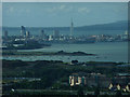
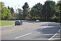
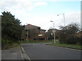
Looking across Southampton Road towards Port Solent
Taken on a misty afternoon in mid December.
Image: © Basher Eyre
Taken: 16 Dec 2008
0.04 miles
6
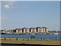
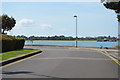
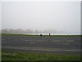
Port Solent Marina
Taken from Southampton Road at High tide
Image: © Richard Greenwood
Taken: 30 Aug 2003
0.05 miles