IMAGES TAKEN NEAR TO
Hillsley Road, PORTSMOUTH, PO6 4LW
Introduction
This page details the photographs taken nearby to Hillsley Road, PO6 4LW by members of the Geograph project.
The Geograph project started in 2005 with the aim of publishing, organising and preserving representative images for every square kilometre of Great Britain, Ireland and the Isle of Man.

There are currently over 7.5m images from over14,400 individuals and you can help contribute to the project by visiting https://www.geograph.org.uk
Image Map
Images are licensed for reuse under creativecommons.org/licenses/by-sa/2.0
Notes
- Clicking on the map will re-center to the selected point.
- The higher the marker number, the further away the image location is from the centre of the postcode.
Image Listing (67 Images Found)
Images are licensed for reuse under creativecommons.org/licenses/by-sa/2.0
Image
Details
Distance
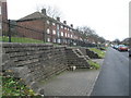
1
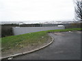
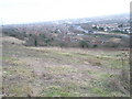
View from western end of Hillsley Road over the M27 and out into the harbour
Image: © Basher Eyre
Taken: 20 Dec 2008
0.02 miles
3
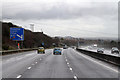
M27 Approaching Junction 12
On the outskirts of Fareham in a short sharp shower.
Image: © Martin Addison
Taken: 16 Mar 2013
0.03 miles
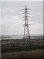
4
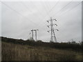
Looking across to Hillsley Road from just past the pylon on Portsdown Hill
Image: © Basher Eyre
Taken: 20 Dec 2008
0.03 miles
5
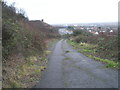
Very end of track from James Callaghan Drive to Hillsley Road
Image: © Basher Eyre
Taken: 20 Dec 2008
0.04 miles
6
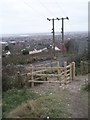
New gate at the bottom of the footpath from James Callaghan Drive to Hillsley Road
Image: © Basher Eyre
Taken: 20 Dec 2008
0.04 miles
7
Path leading down to Hillsley Road, Paulsgrove from James Callaghan Drive
Image: © Basher Eyre
Taken: 20 Dec 2008
0.04 miles
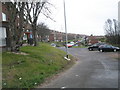
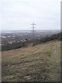
9
Looking down into Paulsgrove from Portsdown Hill
Image: © Basher Eyre
Taken: 20 Dec 2008
0.04 miles