IMAGES TAKEN NEAR TO
Clocktower Drive, SOUTHSEA, PO4 9XR
Introduction
This page details the photographs taken nearby to Clocktower Drive, PO4 9XR by members of the Geograph project.
The Geograph project started in 2005 with the aim of publishing, organising and preserving representative images for every square kilometre of Great Britain, Ireland and the Isle of Man.

There are currently over 7.5m images from over14,400 individuals and you can help contribute to the project by visiting https://www.geograph.org.uk
Image Map
Images are licensed for reuse under creativecommons.org/licenses/by-sa/2.0
Notes
- Clicking on the map will re-center to the selected point.
- The higher the marker number, the further away the image location is from the centre of the postcode.
Image Listing (267 Images Found)
Images are licensed for reuse under creativecommons.org/licenses/by-sa/2.0
Image
Details
Distance
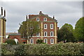
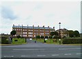
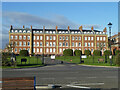
4
Eastney Barracks
Grand buildings on Eastney Esplanade which were home to the Royal Marines.
http://www.royalmarinesmuseum.co.uk/
Image: © Colin Smith
Taken: 25 Mar 2012
0.03 miles

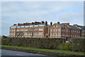
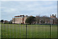
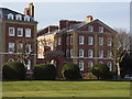
8
Eastney House
Housing in former barracks at Eastney.
Image: © David Martin
Taken: 23 Oct 2016
0.04 miles
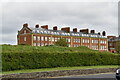
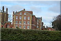
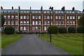
10
Teapot Row, Eastney
Now flats, formerly part of the Royal Marines Eastney barracks. A grade II listed building of the 1860s.
Image: © Robin Webster
Taken: 8 Dec 2013
0.04 miles