IMAGES TAKEN NEAR TO
Collins Road, SOUTHSEA, PO4 9NZ
Introduction
This page details the photographs taken nearby to Collins Road, PO4 9NZ by members of the Geograph project.
The Geograph project started in 2005 with the aim of publishing, organising and preserving representative images for every square kilometre of Great Britain, Ireland and the Isle of Man.

There are currently over 7.5m images from over14,400 individuals and you can help contribute to the project by visiting https://www.geograph.org.uk
Image Map
Images are licensed for reuse under creativecommons.org/licenses/by-sa/2.0
Notes
- Clicking on the map will re-center to the selected point.
- The higher the marker number, the further away the image location is from the centre of the postcode.
Image Listing (381 Images Found)
Images are licensed for reuse under creativecommons.org/licenses/by-sa/2.0
Image
Details
Distance

2
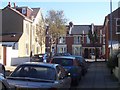
Lindley Avenue
Looking east along Lindley Avenue towards Chitty Road.
Image: © George Munson
Taken: 29 Oct 2008
0.06 miles
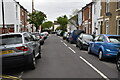
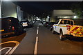
6

Junction of Highland Road and Owen Street
Image: © Basher Eyre
Taken: 11 Oct 2008
0.08 miles
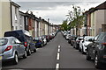
9
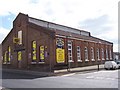
Converted Factory-Portsmouth
This builders merchants on the corner of Ward Rd and Highlands Rd was once a factory. Possibly corsets. If anyone knows different please let me know.
Image: © Colin Babb
Taken: 5 Apr 2008
0.08 miles
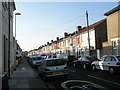
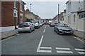
10

Looking southwards down Highland Street
Image: © Basher Eyre
Taken: 11 Oct 2008
0.08 miles