IMAGES TAKEN NEAR TO
Longshore Way, SOUTHSEA, PO4 8LS
Introduction
This page details the photographs taken nearby to Longshore Way, PO4 8LS by members of the Geograph project.
The Geograph project started in 2005 with the aim of publishing, organising and preserving representative images for every square kilometre of Great Britain, Ireland and the Isle of Man.

There are currently over 7.5m images from over14,400 individuals and you can help contribute to the project by visiting https://www.geograph.org.uk
Image Map
Images are licensed for reuse under creativecommons.org/licenses/by-sa/2.0
Notes
- Clicking on the map will re-center to the selected point.
- The higher the marker number, the further away the image location is from the centre of the postcode.
Image Listing (113 Images Found)
Images are licensed for reuse under creativecommons.org/licenses/by-sa/2.0
Image
Details
Distance

8
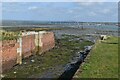
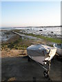
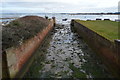
Disused sea lock at Eastney
Although no longer operational as a lock, the chamber provides access to a small tidal basin.
Image: © David Martin
Taken: 25 Sep 2023
0.04 miles