IMAGES TAKEN NEAR TO
Old Canal, SOUTHSEA, PO4 8JA
Introduction
This page details the photographs taken nearby to Old Canal, PO4 8JA by members of the Geograph project.
The Geograph project started in 2005 with the aim of publishing, organising and preserving representative images for every square kilometre of Great Britain, Ireland and the Isle of Man.

There are currently over 7.5m images from over14,400 individuals and you can help contribute to the project by visiting https://www.geograph.org.uk
Image Map
Images are licensed for reuse under creativecommons.org/licenses/by-sa/2.0
Notes
- Clicking on the map will re-center to the selected point.
- The higher the marker number, the further away the image location is from the centre of the postcode.
Image Listing (164 Images Found)
Images are licensed for reuse under creativecommons.org/licenses/by-sa/2.0
Image
Details
Distance
3
Small Hut
Small Hut in grounds of Hester Road Family Centre
Image: © Simon Camps
Taken: 9 Jun 2013
0.05 miles
4
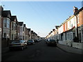
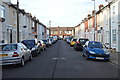
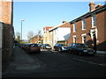
Looking westwards along Dunbar Road
Taken from junction with Maurice Road and Shirley Avenue.
Image: © Basher Eyre
Taken: 28 Dec 2008
0.05 miles
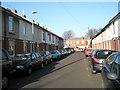
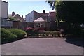
8
Junction of Locksway and Bertie Road
The plaque on the wall says it was the most florally enhanced street in Portsmouth in 2003, 2004, 2005, 2006 and 2007.
Image: © Basher Eyre
Taken: 29 Jul 2009
0.07 miles
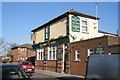
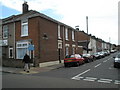
10
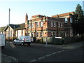
Meon Primary School at the junction of Shelford and Locksway Roads
Image: © Basher Eyre
Taken: 6 Dec 2008
0.08 miles