IMAGES TAKEN NEAR TO
Kingsley Road, SOUTHSEA, PO4 8HN
Introduction
This page details the photographs taken nearby to Kingsley Road, PO4 8HN by members of the Geograph project.
The Geograph project started in 2005 with the aim of publishing, organising and preserving representative images for every square kilometre of Great Britain, Ireland and the Isle of Man.

There are currently over 7.5m images from over14,400 individuals and you can help contribute to the project by visiting https://www.geograph.org.uk
Image Map
Images are licensed for reuse under creativecommons.org/licenses/by-sa/2.0
Notes
- Clicking on the map will re-center to the selected point.
- The higher the marker number, the further away the image location is from the centre of the postcode.
Image Listing (149 Images Found)
Images are licensed for reuse under creativecommons.org/licenses/by-sa/2.0
Image
Details
Distance
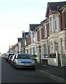
1
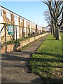
Barriers between Bransbury Park and Kingsley Road
Image: © Basher Eyre
Taken: 28 Dec 2008
0.02 miles
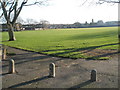
2

The Solent Way (285)
Leaving Bransbury Park there was a cyclist on the footpath. The road onward is Ironbridge Lane. This earlier picture (http://www.geograph.org.uk/photo/1094434 ) shows that little has changed.
Image: © Shazz
Taken: 11 Sep 2012
0.02 miles
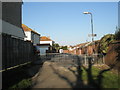
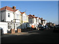
3
Junction of Ironbridge Lane and Kingsley Road
Image: © Basher Eyre
Taken: 28 Dec 2008
0.03 miles
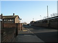
5
Path between flats in Kingsley Road and Bransbury Park
Image: © Basher Eyre
Taken: 28 Dec 2008
0.03 miles
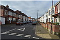
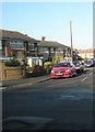
9

Junction of Kingsley Road and Tideway Gardens
Image: © Basher Eyre
Taken: 28 Dec 2008
0.06 miles