IMAGES TAKEN NEAR TO
Cheriton Road, SOUTHSEA, PO4 8FN
Introduction
This page details the photographs taken nearby to Cheriton Road, PO4 8FN by members of the Geograph project.
The Geograph project started in 2005 with the aim of publishing, organising and preserving representative images for every square kilometre of Great Britain, Ireland and the Isle of Man.

There are currently over 7.5m images from over14,400 individuals and you can help contribute to the project by visiting https://www.geograph.org.uk
Image Map
Images are licensed for reuse under creativecommons.org/licenses/by-sa/2.0
Notes
- Clicking on the map will re-center to the selected point.
- The higher the marker number, the further away the image location is from the centre of the postcode.
Image Listing (93 Images Found)
Images are licensed for reuse under creativecommons.org/licenses/by-sa/2.0
Image
Details
Distance
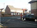
1
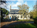
St James Hospital chapel
A grade II listed building, 1879.
Image: © Robin Webster
Taken: 8 Dec 2013
0.08 miles
2
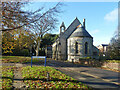
St James Hospital chapel
A grade II listed building, 1879.
Image: © Robin Webster
Taken: 8 Dec 2013
0.08 miles
3
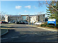
The Orchards
An NHS establishment for mental health inpatients.
Image: © Robin Webster
Taken: 8 Dec 2013
0.08 miles

9
Postbox at the junction of Meryl and Locksway Roads
Image: © Basher Eyre
Taken: 6 Dec 2008
0.11 miles