IMAGES TAKEN NEAR TO
Perth Road, SOUTHSEA, PO4 8EU
Introduction
This page details the photographs taken nearby to Perth Road, PO4 8EU by members of the Geograph project.
The Geograph project started in 2005 with the aim of publishing, organising and preserving representative images for every square kilometre of Great Britain, Ireland and the Isle of Man.

There are currently over 7.5m images from over14,400 individuals and you can help contribute to the project by visiting https://www.geograph.org.uk
Image Map
Images are licensed for reuse under creativecommons.org/licenses/by-sa/2.0
Notes
- Clicking on the map will re-center to the selected point.
- The higher the marker number, the further away the image location is from the centre of the postcode.
Image Listing (234 Images Found)
Images are licensed for reuse under creativecommons.org/licenses/by-sa/2.0
Image
Details
Distance
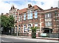
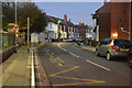
1
Rear of Milton Federated Primary School
Image: © Basher Eyre
Taken: 28 Dec 2008
0.04 miles
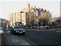
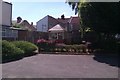
2
Milton Federated Primary School
Taken looking across from Essex Road.
Image: © Basher Eyre
Taken: 29 Jul 2009
0.04 miles
5
Small Hut
Small Hut in grounds of Hester Road Family Centre
Image: © Simon Camps
Taken: 9 Jun 2013
0.05 miles