IMAGES TAKEN NEAR TO
Ningwood Hill, YARMOUTH, PO41 0XW
Introduction
This page details the photographs taken nearby to Ningwood Hill, PO41 0XW by members of the Geograph project.
The Geograph project started in 2005 with the aim of publishing, organising and preserving representative images for every square kilometre of Great Britain, Ireland and the Isle of Man.

There are currently over 7.5m images from over14,400 individuals and you can help contribute to the project by visiting https://www.geograph.org.uk
Image Map
Images are licensed for reuse under creativecommons.org/licenses/by-sa/2.0
Notes
- Clicking on the map will re-center to the selected point.
- The higher the marker number, the further away the image location is from the centre of the postcode.
Image Listing (3 Images Found)
Images are licensed for reuse under creativecommons.org/licenses/by-sa/2.0
Image
Details
Distance
1
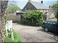
Private road to Hamstead estate from A3054
Image: © John Firth
Taken: 13 May 2010
0.05 miles
2
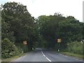
Speed limit signs on Ningwood Common (A3054)
Image: © David Smith
Taken: 16 Jun 2012
0.09 miles
3
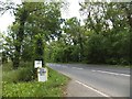
Signs for a farm shop on Ningwood Common
Image: © David Smith
Taken: 16 Jun 2012
0.11 miles