IMAGES TAKEN NEAR TO
Brook Road, YARMOUTH, PO41 0UF
Introduction
This page details the photographs taken nearby to Brook Road, PO41 0UF by members of the Geograph project.
The Geograph project started in 2005 with the aim of publishing, organising and preserving representative images for every square kilometre of Great Britain, Ireland and the Isle of Man.

There are currently over 7.5m images from over14,400 individuals and you can help contribute to the project by visiting https://www.geograph.org.uk
Image Map
Images are licensed for reuse under creativecommons.org/licenses/by-sa/2.0
Notes
- Clicking on the map will re-center to the selected point.
- The higher the marker number, the further away the image location is from the centre of the postcode.
Image Listing (7 Images Found)
Images are licensed for reuse under creativecommons.org/licenses/by-sa/2.0
Image
Details
Distance
1
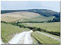
Brook Down
On the Tennyson Trail, a great walk on the western Isle of Wight
Image: © Alan Rolfe
Taken: Unknown
0.09 miles
2
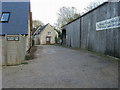
Rear entrance to Chessell Pottery
On Chessell Farm the rear entrance to Chessell Pottery
Image: © Shaun Ferguson
Taken: 31 Oct 2008
0.10 miles
3
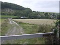
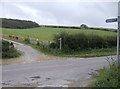
Bridleway descent to Chessell
The woodlands end abruptly. This bridleway descends to the B3349 near Chessell (at the hedge line). Beyond the road is Shalcombe Down, with its prominent disused chalk pit.
Image: © Graham Horn
Taken: 30 Sep 2007
0.11 miles
5
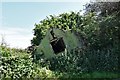
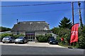
Chessell: An O.S. sheet marked building that won't be for much longer
Image: © Michael Garlick
Taken: 13 Aug 2019
0.12 miles
6
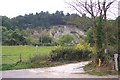
Bridleway to Brighstone Forest
From the B3349 a bridleway ascends towards the extensive woodland collectively known as Brighstone Forest.
Image: © Graham Horn
Taken: 30 Sep 2007
0.14 miles
7
Disused chalk pit
at Shalcombe. The downs around here are heavily scarred with old chalk pits.
Image: © Ron Strutt
Taken: 5 Oct 2005
0.15 miles