IMAGES TAKEN NEAR TO
Malthouse Green, YARMOUTH, PO41 0TT
Introduction
This page details the photographs taken nearby to Malthouse Green, PO41 0TT by members of the Geograph project.
The Geograph project started in 2005 with the aim of publishing, organising and preserving representative images for every square kilometre of Great Britain, Ireland and the Isle of Man.

There are currently over 7.5m images from over14,400 individuals and you can help contribute to the project by visiting https://www.geograph.org.uk
Image Map
Images are licensed for reuse under creativecommons.org/licenses/by-sa/2.0
Notes
- Clicking on the map will re-center to the selected point.
- The higher the marker number, the further away the image location is from the centre of the postcode.
Image Listing (19 Images Found)
Images are licensed for reuse under creativecommons.org/licenses/by-sa/2.0
Image
Details
Distance
1
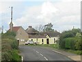
Main Road, Newbridge, Isle of Wight
Main Road passing through the village of Newbridge on the Isle of Wight. This road forms part of the route of the B3401 road linking Newport with Yarmouth.
Image: © Malc McDonald
Taken: 13 Oct 2020
0.04 miles
2
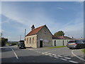
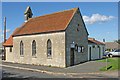
Shalfleet Parish Council Office: October 2015
Image: © Basher Eyre
Taken: 17 Oct 2015
0.08 miles
4
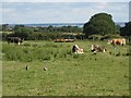
Looking north towards The Solent and the mainland from The Orchards Holiday Park
Image: © Keith Chalmers
Taken: 21 Jun 2009
0.11 miles
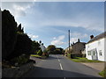
5
Isle of Wight - Newbridge
This is the Newbridge Parish Council and Community Centre. It also houses the Shalfleet Parish Council Offices.
Image: © Brendan and Ruth McCartney
Taken: 17 Oct 2010
0.11 miles
6
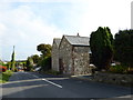
Former Primitive Methodist Chapel, Newbridge
Image: © Basher Eyre
Taken: 17 Oct 2015
0.12 miles
7
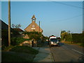
Newbridge Social Club
A thriving social club located in a former church. Used by residents of the Orchards Caravan & Camping site in the same village.
Image: © Ray Stanton
Taken: 2 Jun 2006
0.12 miles
8
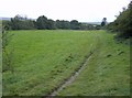
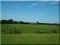
Footpath towards Newbridge
The path leaves the track to Homestead Farm and crosses fields again in the last quarter of a mile approaching Newbridge. The Caul Bourne is to the left and the signpost at the road junction at SZ413875 can just be seen at the termination of the path.
Image: © Graham Horn
Taken: 30 Sep 2007
0.13 miles
9
Homestead Farm
The mainland is just visible in the far distance.
Image: © Ray Stanton
Taken: 3 Jun 2006
0.14 miles
10
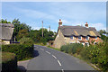
Thatched cottages, Newbridge
On the B3401.
Image: © Robin Webster
Taken: 24 Sep 2016
0.14 miles