IMAGES TAKEN NEAR TO
Westhill Lane, YARMOUTH, PO41 0SA
Introduction
This page details the photographs taken nearby to Westhill Lane, PO41 0SA by members of the Geograph project.
The Geograph project started in 2005 with the aim of publishing, organising and preserving representative images for every square kilometre of Great Britain, Ireland and the Isle of Man.

There are currently over 7.5m images from over14,400 individuals and you can help contribute to the project by visiting https://www.geograph.org.uk
Image Map
Images are licensed for reuse under creativecommons.org/licenses/by-sa/2.0
Notes
- Clicking on the map will re-center to the selected point.
- The higher the marker number, the further away the image location is from the centre of the postcode.
Image Listing (47 Images Found)
Images are licensed for reuse under creativecommons.org/licenses/by-sa/2.0
Image
Details
Distance
1
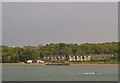
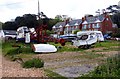
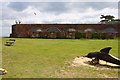
Houses, Holiday Apartments, Businesses and the old Pier, near Fort Victoria, Isle of Wight - 2
Image: © Terry Robinson
Taken: 20 May 2013
0.04 miles
2

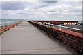
Houses, Holiday Apartments, Businesses and the old Pier, near Fort Victoria, Isle of Wight - 1
Image: © Terry Robinson
Taken: 20 May 2013
0.06 miles

9
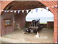
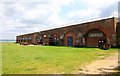
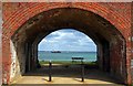
Gun casemate at Fort Victoria
A 68-pounder at Fort Victoria.
Image: © Martin Speck
Taken: 21 Sep 2016
0.08 miles