IMAGES TAKEN NEAR TO
Basketts Lane, YARMOUTH, PO41 0PY
Introduction
This page details the photographs taken nearby to Basketts Lane, PO41 0PY by members of the Geograph project.
The Geograph project started in 2005 with the aim of publishing, organising and preserving representative images for every square kilometre of Great Britain, Ireland and the Isle of Man.

There are currently over 7.5m images from over14,400 individuals and you can help contribute to the project by visiting https://www.geograph.org.uk
Image Map
Images are licensed for reuse under creativecommons.org/licenses/by-sa/2.0
Notes
- Clicking on the map will re-center to the selected point.
- The higher the marker number, the further away the image location is from the centre of the postcode.
Image Listing (462 Images Found)
Images are licensed for reuse under creativecommons.org/licenses/by-sa/2.0
Image
Details
Distance
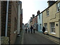
7
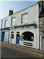
High Street, Yarmouth, Isle of Wight
Looking eastwards.
Image: © Christine Matthews
Taken: 28 Sep 2009
0.05 miles
8
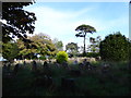
St James's Burial Ground, Yarmouth: mid October 2015
(between Martine Close and Tennyson Road)
Image: © Basher Eyre
Taken: 17 Oct 2015
0.05 miles
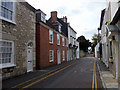
10

House on the High Street
This must be new build, as Streetview July 2009 shows there is an older style house on this site.
Image: © Dave Croker
Taken: 10 Jul 2018
0.06 miles