IMAGES TAKEN NEAR TO
Craneswater Avenue, SOUTHSEA, PO4 0PB
Introduction
This page details the photographs taken nearby to Craneswater Avenue, PO4 0PB by members of the Geograph project.
The Geograph project started in 2005 with the aim of publishing, organising and preserving representative images for every square kilometre of Great Britain, Ireland and the Isle of Man.

There are currently over 7.5m images from over14,400 individuals and you can help contribute to the project by visiting https://www.geograph.org.uk
Image Map
Images are licensed for reuse under creativecommons.org/licenses/by-sa/2.0
Notes
- Clicking on the map will re-center to the selected point.
- The higher the marker number, the further away the image location is from the centre of the postcode.
Image Listing (540 Images Found)
Images are licensed for reuse under creativecommons.org/licenses/by-sa/2.0
Image
Details
Distance
4
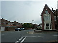
Road junction of Gains Road and St Ronan's Road
Image: © Basher Eyre
Taken: 5 May 2011
0.03 miles
5
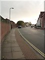
Lamppost in St Ronan's Road
This was the course of the old Southsea Railway http://en.wikipedia.org/wiki/Southsea_Railway
Image: © Basher Eyre
Taken: 3 Nov 2011
0.03 miles
6
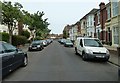
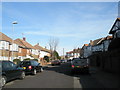
Looking along Gains Road towards St Ronan's Road
Image: © Basher Eyre
Taken: 5 May 2011
0.03 miles
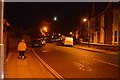
8
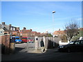
Craneswater Avenue
Taken whilst following the route of the old Southsea Railway
Image: © Basher Eyre
Taken: 26 Jan 2008
0.04 miles
9
Route of Old Railway
The Southsea Railway came from Albert Road Station (next to the church you can see in the distance) to here and then onto Granada Road.
Image: © Basher Eyre
Taken: 26 Jan 2008
0.04 miles