IMAGES TAKEN NEAR TO
Afton Down, FRESHWATER, PO40 9TY
Introduction
This page details the photographs taken nearby to Afton Down, PO40 9TY by members of the Geograph project.
The Geograph project started in 2005 with the aim of publishing, organising and preserving representative images for every square kilometre of Great Britain, Ireland and the Isle of Man.

There are currently over 7.5m images from over14,400 individuals and you can help contribute to the project by visiting https://www.geograph.org.uk
Image Map
Images are licensed for reuse under creativecommons.org/licenses/by-sa/2.0
Notes
- Clicking on the map will re-center to the selected point.
- The higher the marker number, the further away the image location is from the centre of the postcode.
Image Listing (159 Images Found)
Images are licensed for reuse under creativecommons.org/licenses/by-sa/2.0
Image
Details
Distance
1
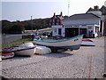
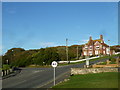
Freshwater Bay - Independent Lifeboat Shop
Picture taken from sea wall facing east towards the lifeboat shop.
Freshwater Lifeboat is run by an independent lifeboat organisation based at Freshwater Bay on the Isle of Wight.
http://lifeboat.p-c-bay.co.uk/
Image: © Alan Swain
Taken: 29 Apr 2007
0.03 miles
2
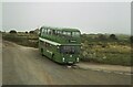
Bus terminus, Freshwater Bay ? 1978
Southern Vectis was the principal operator on the island from the 1930s having come under control of the Southern Railway in 1929. By 1978 it was part of the National Bus Company. Bus 673, a Bristol VR with ECW bodywork, is seen in the standard NBC livery of leaf green, and is representative of what was effectively the standard NBC double deck bus of the period. It is parked at the entrance to the Freshwater Bay Golf Club on Southdown Road waiting for its return to Sandown.
This is one of a series of views featuring buses in the 60s, 70s, and 80s. http://www.geograph.org.uk/search.php?i=137652761
Image: © Alan Murray-Rust
Taken: 10 Sep 1978
0.04 miles
3
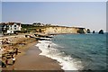
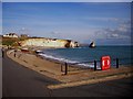
Freshwater Bay and Stag Rock
This is the eastern end of the beach at Freshwater Bay. Stag Rock is so named because allegedly a stag jumped onto it from the mainland to escape capture. It does not seem feasible does it? The base of Arch Rock, a second sea stack that collapsed in 1992, can just be seen. The third sea stack, Mermaid Rock, is hidden behind the promontory.
Image: © Graham Horn
Taken: 19 Jun 2009
0.04 miles
4
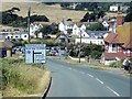
Freshwater Bay
Entering Freshwater Bay via the Military Road.
Image: © David Dixon
Taken: 16 Jul 2013
0.04 miles

7
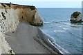
Freshwater Bay Looking East Towards Chalk Cliffs
Image: © dinglefoot
Taken: 3 Oct 2005
0.07 miles
9
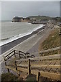
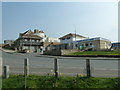
Freshwater: steps on the coast path
The grounds of the house to the right extend right to the edge of the cliff, so the coast path continues by way of these wooden steps onto the beach at Freshwater Bay.
Image: © Chris Downer
Taken: 20 Mar 2014
0.08 miles