IMAGES TAKEN NEAR TO
Norton Green, FRESHWATER, PO40 9RU
Introduction
This page details the photographs taken nearby to Norton Green, PO40 9RU by members of the Geograph project.
The Geograph project started in 2005 with the aim of publishing, organising and preserving representative images for every square kilometre of Great Britain, Ireland and the Isle of Man.

There are currently over 7.5m images from over14,400 individuals and you can help contribute to the project by visiting https://www.geograph.org.uk
Image Map
Images are licensed for reuse under creativecommons.org/licenses/by-sa/2.0
Notes
- Clicking on the map will re-center to the selected point.
- The higher the marker number, the further away the image location is from the centre of the postcode.
Image Listing (8 Images Found)
Images are licensed for reuse under creativecommons.org/licenses/by-sa/2.0
Image
Details
Distance
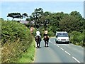
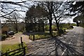
3
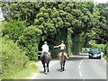
Horse Riders on Hill Lane
Two riders approaching Hill Farm Stables.
Image: © David Dixon
Taken: 16 Jul 2013
0.20 miles
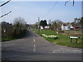
5
South Wight : Hill Lane
Hill Lane with an entrance to St Andrews on the left.
Image: © Lewis Clarke
Taken: 2 Apr 2012
0.21 miles
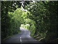
6
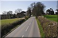
South Wight : Hill Lane
Looking along Hill Lane which heads towards Totland.
Image: © Lewis Clarke
Taken: 2 Apr 2012
0.22 miles
7
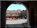
Golden Hill Fort 2003
Taken in May 2003 when the Fort was between incarnations. Its life as a nightclub/rave venue and broadcasting station was over and planning consent for conversion to luxury dwellings was granted in this year.
Image: © Jacqueline Barber
Taken: 15 May 2003
0.22 miles
8
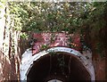
Golden Hill Fort 2003
Entrance to the Fort in May 2003
Image: © Jacqueline Barber
Taken: 25 May 2003
0.22 miles