IMAGES TAKEN NEAR TO
Heathfield Road, FRESHWATER, PO40 9LH
Introduction
This page details the photographs taken nearby to Heathfield Road, PO40 9LH by members of the Geograph project.
The Geograph project started in 2005 with the aim of publishing, organising and preserving representative images for every square kilometre of Great Britain, Ireland and the Isle of Man.

There are currently over 7.5m images from over14,400 individuals and you can help contribute to the project by visiting https://www.geograph.org.uk
Image Map
Images are licensed for reuse under creativecommons.org/licenses/by-sa/2.0
Notes
- Clicking on the map will re-center to the selected point.
- The higher the marker number, the further away the image location is from the centre of the postcode.
Image Listing (7 Images Found)
Images are licensed for reuse under creativecommons.org/licenses/by-sa/2.0
Image
Details
Distance
1
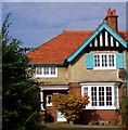
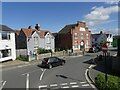
Arts and Crafts House
Colwell Common, Freshwater.
Image: © David Ballard
Taken: 15 Oct 2003
0.06 miles
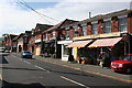
3
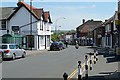
Avenue Road, Freshwater
The main shopping street in Freshwater. Although it does not have many shops it still has four traditional banks, one each of the big four, but seemingly no former building societies.
Image: © Graham Horn
Taken: 24 Jun 2009
0.22 miles
4
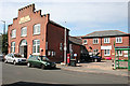
The Memorial Hall
The hall was originally built as a drill hall.
Image: © Anne Burgess
Taken: 1 Jul 2014
0.23 miles
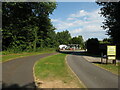
6
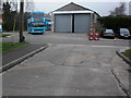
Freshwater bus depot
This bus depot in Princes Road, Freshwater, has now been demolished to make way for a new housing development.
Image: © Ken Fry
Taken: 30 Mar 2006
0.23 miles
7
Avenue Road
The tautologically named main street of Freshwater.
Image: © Anne Burgess
Taken: 1 Jul 2014
0.25 miles