IMAGES TAKEN NEAR TO
Queens Road, FRESHWATER, PO40 9HE
Introduction
This page details the photographs taken nearby to Queens Road, PO40 9HE by members of the Geograph project.
The Geograph project started in 2005 with the aim of publishing, organising and preserving representative images for every square kilometre of Great Britain, Ireland and the Isle of Man.

There are currently over 7.5m images from over14,400 individuals and you can help contribute to the project by visiting https://www.geograph.org.uk
Image Map
Images are licensed for reuse under creativecommons.org/licenses/by-sa/2.0
Notes
- Clicking on the map will re-center to the selected point.
- The higher the marker number, the further away the image location is from the centre of the postcode.
Image Listing (11 Images Found)
Images are licensed for reuse under creativecommons.org/licenses/by-sa/2.0
Image
Details
Distance
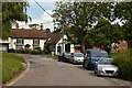
1
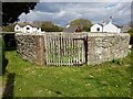
Village Pound
This is the circular Town Pound at Pound Green, Freshwater. It dates from the 18th century, has walls 5 feet high and was restored in 2008. It sits within the Pound Green Conservation Area. The 1861 Ordnance Survey map labels this structure as ‘Pinfold’, although the 1909 map reverts to ‘Pound’. This is where straying animals would be kept until claimed by the owner upon payment of a fee.
Image: © Andrew Culley
Taken: 29 Apr 2021
0.05 miles
2
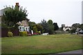
Pound Green, Freshwater
The original circular village pound, built of stone and used for keeping stray animals, still stands on the green.
Image: © Ron Strutt
Taken: 5 Oct 2005
0.09 miles
3
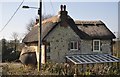
Locksley : Farringford Cottage
Farringford Cottage on Bedbury Lane near Totland.
Image: © Lewis Clarke
Taken: 2 Apr 2012
0.17 miles
4
Access to Farringford Park
Farringford House was owned by Alfred Lord Tennyson. It is now a museum with self-catering cottages in the grounds. The access road is a public right of way leading to Tennyson Down.
Image: © John Lucas
Taken: 4 Sep 2019
0.19 miles
6

Freshwater old fire station
Freshwater old fire station, Queens Road, Freshwater, Isle Of Wight
Image: © Kevin Hale
Taken: 18 May 2009
0.21 miles
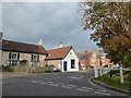
7
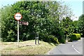
Queen's Road, Middleton
For the interest in this sign see Image Middleton is one of five hamlets making up Freshwater: Weston, Norton, Middleton, Easton, and ... Freshwater Bay (which was originally called Southtown).
Image: © Graham Horn
Taken: 24 Jun 2009
0.21 miles
8
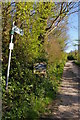
Locksley: lane to Farringford Farm
Image: © Christopher Hilton
Taken: 15 Apr 2014
0.22 miles
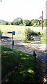
9
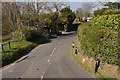
Locksley : Middleton Road
A road heading off from Bedbury Lane.
Image: © Lewis Clarke
Taken: 2 Apr 2012
0.22 miles
10
Former Bible Christian Chapel, Brookside Road
Also see https://en.wikipedia.org/wiki/Bible_Christian_Church
Image: © Basher Eyre
Taken: 17 Oct 2015
0.22 miles