IMAGES TAKEN NEAR TO
West High Down, TOTLAND BAY, PO39 0JH
Introduction
This page details the photographs taken nearby to West High Down, PO39 0JH by members of the Geograph project.
The Geograph project started in 2005 with the aim of publishing, organising and preserving representative images for every square kilometre of Great Britain, Ireland and the Isle of Man.

There are currently over 7.5m images from over14,400 individuals and you can help contribute to the project by visiting https://www.geograph.org.uk
Image Map
Images are licensed for reuse under creativecommons.org/licenses/by-sa/2.0
Notes
- Clicking on the map will re-center to the selected point.
- The higher the marker number, the further away the image location is from the centre of the postcode.
Image Listing (193 Images Found)
Images are licensed for reuse under creativecommons.org/licenses/by-sa/2.0
Image
Details
Distance
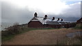
1
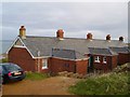
Coastguard Cottages near the Needles
Three of these four cottages are let by the National Trust as holiday accommodation - a windswept, but dramatic spot. They are named after ships wrecked on the Needles - Varvassi, Irex and Pomone.
Image: © Derek Harper
Taken: 5 Jan 2005
0.00 miles
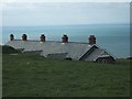
2
Needles Coastguard Cottages
Now available as holiday lets.
Image: © John Lucas
Taken: 4 Sep 2019
0.01 miles
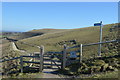
3
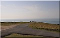
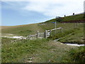
South Wight : West High Down & Road
A small road heading along the top of West High Down.
Image: © Lewis Clarke
Taken: 2 Apr 2012
0.01 miles
4
View Near Coastguard Cottages, The Needles, Isle of Wight
Several of the cottages are owned by the National Trust, and let as holiday homes. The headland provides some protection for the cottages; an excellent viewpoint, overlooking the sea and the coastline of Hampshire and Dorset.
http://www.nationaltrustcottages.co.uk/south_east/isle_of_wight/irex/122
Image: © Peter Trimming
Taken: 10 Apr 2010
0.02 miles
5
Coastguard cottages near The Needles
These cottages are owned by The National Trust and are available for holiday rental. You can't spend a night any further west on the Isle of Wight than this, but the wind can be ferocious!
Image: © John Welford
Taken: 10 Nov 2014
0.02 miles
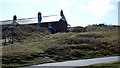
8
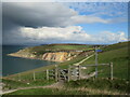
Path on Tennyson Down, near Alum Bay
A path leading onto Tennyson Down on the Isle of Wight. Tennyson Down is managed by the Naitonal Trust: https://www.nationaltrust.org.uk/the-needles-headland-and-tennyson-down
This view looks over Alum Bay, with its distinctive multi-coloured sand cliffs.
Dark clouds loom to the left, bringing rain which fell about 15 minutes after this photo was taken.
Image: © Malc McDonald
Taken: 13 Oct 2020
0.03 miles
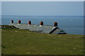
10
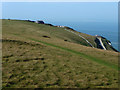
West High Down
Coastguard Cottages and road to Needles Battery
Image: © Chris Gunns
Taken: 1 Oct 2011
0.04 miles