IMAGES TAKEN NEAR TO
Upper House Lane, VENTNOR, PO38 2HD
Introduction
This page details the photographs taken nearby to Upper House Lane, PO38 2HD by members of the Geograph project.
The Geograph project started in 2005 with the aim of publishing, organising and preserving representative images for every square kilometre of Great Britain, Ireland and the Isle of Man.

There are currently over 7.5m images from over14,400 individuals and you can help contribute to the project by visiting https://www.geograph.org.uk
Image Map
Images are licensed for reuse under creativecommons.org/licenses/by-sa/2.0
Notes
- Clicking on the map will re-center to the selected point.
- The higher the marker number, the further away the image location is from the centre of the postcode.
Image Listing (21 Images Found)
Images are licensed for reuse under creativecommons.org/licenses/by-sa/2.0
Image
Details
Distance
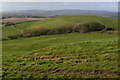
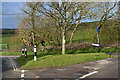
1
Bridleway to Chale
The buildings in the centre of the picture are at Tithe House Farm.
Image: © Shazz
Taken: 12 Oct 2015
0.00 miles
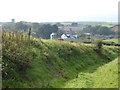
3
Small green at the end of Upper House Lane
Image: © David Martin
Taken: 17 Feb 2018
0.11 miles
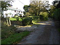
5
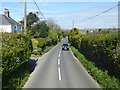
B3399 Chale Street
Looking from a route 6 bus bound for Newport.
Image: © Robin Webster
Taken: 14 Apr 2017
0.17 miles
6
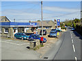
Garage, Chale
On Church Place, B3399.
Image: © Robin Webster
Taken: 14 Apr 2017
0.18 miles
7
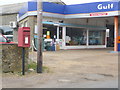
Chale: postbox № PO38 241, Church Place
A modern postbox replacing the one in the wall of the old post office (Image), outside the garage a couple of hundred yards further along Church Place.
Image: © Chris Downer
Taken: 20 Mar 2014
0.19 miles
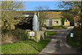
8
![The Beeches [formerly Arnishee], Chale](https://s2.geograph.org.uk/geophotos/01/68/96/1689606_b0aa2888_120x120.jpg)
The Beeches [formerly Arnishee], Chale
Image: © Andrew Davidson
Taken: 1 Aug 2007
0.20 miles