IMAGES TAKEN NEAR TO
Marlborough Road, VENTNOR, PO38 1TE
Introduction
This page details the photographs taken nearby to Marlborough Road, PO38 1TE by members of the Geograph project.
The Geograph project started in 2005 with the aim of publishing, organising and preserving representative images for every square kilometre of Great Britain, Ireland and the Isle of Man.

There are currently over 7.5m images from over14,400 individuals and you can help contribute to the project by visiting https://www.geograph.org.uk
Image Map
Images are licensed for reuse under creativecommons.org/licenses/by-sa/2.0
Notes
- Clicking on the map will re-center to the selected point.
- The higher the marker number, the further away the image location is from the centre of the postcode.
Image Listing (536 Images Found)
Images are licensed for reuse under creativecommons.org/licenses/by-sa/2.0
Image
Details
Distance
1

Ventnor from Littleton Down
With the former site of Ventnor railway station immediately below, now an industrial estate. The station closed in 1966.
Image: © Paul Coueslant
Taken: 6 Oct 2015
0.03 miles
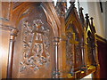
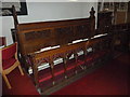
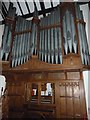
2
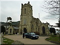
Saint Catherine, Ventnor: February 2013
Image: © Basher Eyre
Taken: 23 Feb 2013
0.04 miles
4
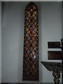
Saint Catherine, Ventnor: stained glass window (a)
Image: © Basher Eyre
Taken: 23 Feb 2013
0.04 miles
5
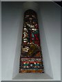
Saint Catherine, Ventnor: stained glass window (b)
Image: © Basher Eyre
Taken: 23 Feb 2013
0.04 miles
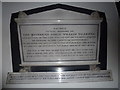
9
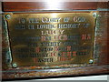
Saint Catherine, Ventnor: memorial (iii)
Image: © Basher Eyre
Taken: 23 Feb 2013
0.04 miles
